The Political Map of India
India comprises of a total of 29 states along with seven union territories.
Here’s a brief overview of India.
| Capital of India | New Delhi |
| No. of States in India | 29 |
| Number of Union Territories in India | 7 |
| Type of Government | Federal Democratic Republic |
| Geographic coordinates | 20 00 N, 77 00 E |
| Land Area | 3,287,263 sq km |
| Population | 1,326,801,576 |
| Languages | Hindi, English, Urdu, Tamil |
| Literacy | 74.04% |
| Total No. of Airports | 125 |
| Total Railway Lines (total track length of network) | 115,000 km |
Broadly, India is divided into six major zones: East India, West India, North India, South India, Northeast India and Central India.
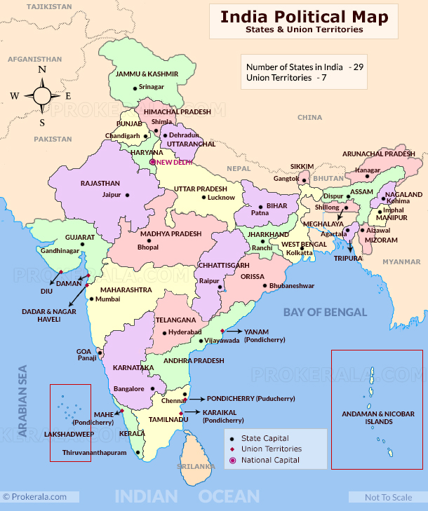
Eastern India
- includes the states of Bihar, Jharkhand, Orissa , West Bengal and a union territory Andaman and Nicobar Islands.
- The Eastern zone covers a total area of 418,323 sq km.
- The dominant language in West Bengal is Bengali in the state of West Bengal
- Odia and Hindi are the principal languages in the states of Orissa and Jharkhand. English, Maithili, Nepali and Urdu are other languages spoken in the Eastern India.
The Western region of India
- covers a total area of 508, 052 Sq.km.
- Includes states like Gujarat, Goa and Maharashtra with the Union Territories of Daman and Diu and Dadra and Nagar Haveli.
- Mumbai is the financial capital of India and is also capital city of Maharashtra.
- Official languages of the states lying in Western region of India include Marathi, Gujarati, Konkani and English.
The six states of North India are:
- Includes states like Jammu and Kashmir, Himachal Pradesh, Uttar Pradesh, Uttarakhand , Punjab, Haryana with union territories of Delhi (National Capital Territory) and Chandigarh.
- The most populous cities of North India are New Delhi, Jaipur, Lucknow, Indore, Patna and Chandigarh.
Southern India
- includes states like Tamil Nadu, Karnataka, Kerala, Andhra Pradesh, Telangana with the union territories of Lakshadweep and Puducherry.
- Over 19.31% of India’s total area is occupied by these states and union territories.
- Bengaluru, the capital of Karnataka, is known as the ‘Silicon Valley of India’ because it is the country’s leading exporter in IT sector.
- Most populous cities of South India include Bengaluru, Hyderabad, Chennai, Coimbatore, Cochin and Mysore.
North East India
- includes Arunachal Pradesh, Assam , Meghalaya, Tripura, Mizoram, Manipur, Nagaland and the Himalayan state of Sikkim.
The Central zone of India primarily refers to Madhya Pradesh and the newly formed state of Chhattisgarh.
UPDATE: After Telangana split from Andhra Pradesh to become the newest — 29th — State of India on 2nd June 2014 with Hyderabad as the capital of the new state and Amravathi as the capital of Andhra Pradesh, we have made a refreshed and updated list of all the states and their capital cities.
As already discussed, there are a total of 29 states and 7 Union Territories in India. The states of India along with their capital cities are as follows:
| States (in alphabetical order) | Capital City |
| Andhra Pradesh | Amravathi [*Hyderabad initially] |
| Arunachal Pradesh | Itanagar |
| Assam | Dispur |
| Bihar | Patna |
| Chhattisgarh | Raipur |
| Goa | Panaji |
| Gujarat | Gandhinagar |
| Haryana | Chandigarh (shared with Punjab) |
| Himachal Pradesh | Shimla |
| Jammu & Kashmir | Srinagar (Summer) Jammu (Winter) |
| Jharkhand | Ranchi |
| Karnataka | Bangalore |
| Kerala | Thiruvananthapuram |
| Madhya Pradesh | Bhopal |
| Maharashtra | Mumbai |
| Manipur | Imphal |
| Meghalaya | Shillong |
| Mizoram | Aizawl |
| Nagaland | Kohima |
| Odisha (Orissa) | Bhubaneshwar |
| Punjab | Chandigarh (shared with Haryana) |
| Rajasthan | Jaipur |
| Sikkim | Gangtok |
| Tamil Nadu | Chennai |
| Telangana (from June 2, 2014) | Hyderabad |
| Tripura | Agartala |
| Uttar Pradesh | Lucknow |
| Uttarakhand | Dehradun |
| West Bengal | Kolkata |
| Union territory (in alphabetical order) | Capital City |
| Andaman and Nicobar Islands | Port Blair |
| Chandigarh | Chandigarh |
| Dadra and Nagar Haveli | Silvassa |
| Daman and Diu | Daman |
| Lakshadweep | Kavaratti |
| Delhi – National Capital Territory | Delhi |
| Puducherry (Pondicherry) | Pondicherry |
This was an insight into the political map of India.