Class 11 Geography Notes Chapter 1 India: Location
Historical Perspective:
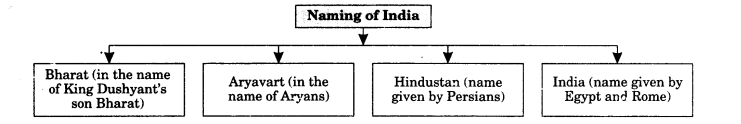
Ancient King Dushyant had a son whose name was Bharat. In his name, this country was named as Bharat. According to some scholars, Bharat name was given according to a caste living in India in ancient times.
The name ‘India’ was originated from Indus valley civilization.
Huns, Egyptians, Persians, and other countrymen used to enter India by crossing Indus river. The word Hindu originated from Sindhu. People from these countries used to pronounce S as H and so they called Sindhu as Hindu.
Egyptians and Romans used to call Indus as Sindhu valley and eastern part of it as India.
India’s boundaries are clear from geographical point of viewT. There are great mountains on its north-east and north-west side and there are great ocean in its south-east and south-west sides. Foreigners can enter India by crossing Khyber and Bolan straits.
Among all the living civilisation of the world, India is probably the oldest.
Around 2000-3000 BC a group of food gatherers developed a highly developed civilization.
With the destruction of Harappa civilization, a new civilization took birth in India. In 1500 BC, Aryans came to India which gave birth to Vedic culture.
According to historians, Aryans had not come from some other place. They had a community. They were divided in many castes. They kept roaming in Persia in West, Ganga Valley in the east and regions of Caspian Sea.
By 1000 BC, Aryans reached to the southern comer of India to tie India in a cultural knot. According to Aryans, the society was divided into four Vama: Brahmin, Kshatriya, Vaishya and Shudra.
Study of Ved, Prayers, etc were the responsibility of Brahmins. Saving people from enemies was the responsibility of Kshatriyas. Vaishyas used to take care of business activities and economy of the nation. Shudra used to provide labour for different tasks. It was occupational classification on the basis of activity.
Present Perspective:
India is the seventh largest country in the world with total area of 32,87,263 sq. km which is 2.42 per cent of the world’s area. It is the second most populous country after China in the world with a population of 1.21 billion.
The mainland of India, extends from Kashmir in the north to Kanniyakumari in the south and Arunachal Pradesh in the east to Gujarat in the west. India extends from territorial limit further extends towards the sea upto 12 nautical miles (about 21.9 km) from the coast. India lies entirely in the Northern hemisphere. The mainland extends between latitudes 8°4′ N (Kanniyakumari, Cape Caverian) and 37° 6′ N (Indira col, Jammu and Kashmir) and longitudes 68° 7′ E (Dwarka, Gujarat) and 97° 25′ E (Sadiya, Arimachal Pradesh).
Longitudinal extent of India is 68° 7′ to 97° 25′ E-(29°). The latitudinal and longitudinal extent of India are roughly about 30 degrees, whereas the actual distance measured from north to south extremity is 3,214 km, and that from east to west is only 2,933 km.
This difference is based on the fact that the distance between two longitudes decreases towards the poles whereas the distance between two latitudes remains the same everywhere.
The southern part of the country lies within the tropics and the northern part lies in the sub¬tropical zone or the warm temperate zone. This location is responsible for large variations in landforms, climate, soil types and natural vegetation in the country.
There is a variation of nearly 30 degrees from west to east in India which causes a time difference of nearly two hours between the easternmost and the westernmost parts of our country.
While the sun rises in the northeastern states about two hours earlier as compared to Jaisalmer, the watches in Dibrugarh, Imphal in the east and Jaisalmer, Bhopal or Chennai in the other parts of India shows the same time because we follow one standard time all over India called Indian Standard Time (1ST)
There is a general understanding among the countries of the world to select the standard meridian in multiples of 7°30′ of longitude. That is why 82°30′ E has been selected as the ‘standard meridian’ of India. Indian Standard Time is ahead of Greenwich Mean Time by 5 hours and 30 minutes. There are some countries where there are more than one standard meridian due to their vast east-to-west extent. For example, the USA has seven time zones.
The size of India has endowed her with great physical diversity. India is gifted with the presence of lofty mountains in the north; large rivers such as Ganga, Brahmaputra, Mahanadi, Krishna, Godavari and Kaveri; green forested hills in northeast and south India; and the vast sandy expanse of Marusthali.
India has second position in terms of Agrarian land after USA.
It is bounded by the Himalayas in the north, Hindukush and Sulaiman ranges in the north-west, Purvachal hills in the north-east and by the large expanse of the Indian ocean in the south, it forms a great geographic entity known as the Indian subcontinent. It includes the countries — Pakistan, Nepal, Bhutan, Bangladesh and India.
India’s land length is 15,200 km and it has a coastline of 6,100 km in the mainland and 7,517 km in the entire geographical coast of the mainland plus the island groups Andaman and Nicobar located in the Bay of Bengal and the Lakshadweep in the Arabian Sea. Thus India, as a country, is a physically diverse land providing occurrence of varied resources.
India is located in the south-central part of the continent of Asia, bordering the Indian ocean and its two arms extending in the form of Bay of Bengal and the Arabian Sea. This maritime location of Peninsular India has provided links to its neighbouring regions through the sea and air routes. Sri Lanka and Maldives are the two island countries located in the Indian Ocean, which are our neighbours. Sri Lanka is separated from India by the Gulf of Mannar and Palk Strait.
India has 29 states and 7 union territories. It is situated in the middle of western Asia and Eastern Asia.
Class 11 Geography Notes Chapter 1 Important Terms:
- Siam: Old name of Thailand.
- Aryavarta: Old name of India. It was in the name of Aryans who came to India in ancient times.
- Indira Point: It is the southernmost part of India.
- Varna System: According to Aryans the society was divided into four Varna: Brahmin, Kshatriya, Vaishya and Shudra.
- Suba: In Mughal periods, states were called suba.
- Sarkar: Districts in Mughal period were called sarkar.
- Mahal: Towns and villages were called mahal in Mughal period.
- Subcontinent: Himalayas in the north, Hindukush and Sulaiman ranges in the north¬west, Purvachal hills in the north-east and by the large expanse of the Indian ocean in the south forms a great geographic entity known as the Indian subcontinent. It includes the countries — Pakistan, Nepal, Bhutan, Bangladesh and India.