CBSE Previous Year Question Papers Class 12 Geography 2016 Delhi
Time allowed : 3 hours
Maximum marks: 70
General Instructions :
- There are 22 questions in all.
- All questions are compulsory.
- Question number 1 to 7 are very short-answer questions carrying 1 mark each. Answer to each of these questions should not exceed 40
- Question numbers 8 to 13 are short-answer questions carrying 3 marks each. Answer to each of these questions should not exceed 80-100 words.
- Question numbers 14 to 20 are long-answer questions carrying 5 marks each. Answer to each of these questions should not exceed 150
- Question numbers 21 to 22 are related to identification or locating and labelling of geographical features on maps, carrying 5 marks each.
- Outline maps of the World and India provided to you must be attached within your answer-book.
- Use of templates or stencils for drawing outline maps is allowed.
** Answer has not been given due to change in present syllabus.
CBSE Previous Year Question Papers Class 12 Geography 2016 Delhi Set – I
Question 1.
Why is the age structure considered an important indicator of population composition ? Give one reason. [1]
Answer:
Age structure represents the number of people of different age groups. This is an important indicator of population composition, r since a large size of population in the age group of 15- 59 indicates a large working population. A greater proportion of population above 60 years represents an ageing population which requires more expenditure on health care facilities, Similarly high proportion of young population would mean that the region has a high birth rate and the population is youthful.
Question 2.
“Leading a long and healthy life is an important aspect of human development.” Give an argument to support the statement. ‘ [1]
Answer:
Living a long and healthy life indicates access to resources, health facilities and improved ‘ levels of nutrition intake. Hence, it is an important aspect of human development.
Question 3.
Agri-business farms are mechanized and large in size.” Examine the statment. [1]
Answer:
This type of farming is mainly found in the case of Extensive Commercial grain farming where wheat is the principal crop, though other crops like corn, barley, oats and rye are also grown. The size of the farm is very large and the entire process of cultivation from ploughing to harvesting are mechanised.
Question 4.
Examine the functioning of World Trade Organisation (WTO). [1]
Answer:
The WTO is the only international organisation dealing with the global rules of trade between nations. It sets the rules for the global trading system and resolves disputes between its member nations. WTO also covers trade in services, such as telecommunication and banking, and others issues such as intellectual rights.
Question 5.
Name the state of India with highest literacy rate as per 2011 census. [1]
Answer:
Kerala.
Question 6.
Which major sea port on the eastern coast of India has a land locked harbour ? [1]
Answer:
Vishakhapatnam Sea-port.
Question 7.
Name the state of India with largest area. [1]
Answer:
Rajasthan.
Question 8.
“The nature and human beings are so intricately intertwined that they can’t be separated.” Substantiate the statement. [3]
Answer:
Man and environment share a reciprocal relationship. In the early stages human activities were controlled and governed by .environment. Man acted as a passive agent. This, is so because the level of technology was very low and the stage of human social development was also primitive. This type of interaction between primitive human society and strong forces of nature was termed as environmental determinism. However, with the passage of time people began to understand their environment and the forces of nature. Physical and human phenomena are often described in metaphors like—face of the earth, eye of the storm, mouth of the river, snout of the glacier, profile of the soil etc.
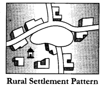
Question 9.
Study the diagram given below and answer the questions that follow : [3 × 1 = 3]
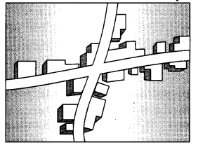
Question 9.1.
Identify and name the given rural settlement pattern.
Answer:
Cross shaped Rural settlement pattern.
Question 9.2.
In which type of areas do we find such type of settlement patterns ?
Answer:
They are usually found in plain areas where roads and railways cut each other at about right angles.
Question 9.3.
Give an important characteristic of this type of settlement pattern.
Answer:
These settlements develop on the cross-roads and houses extend in all the four directions, side by side in a compact fashion.
Question 10.
Study the following diagram and answer the questions that follow: [3 × 1 = 3]
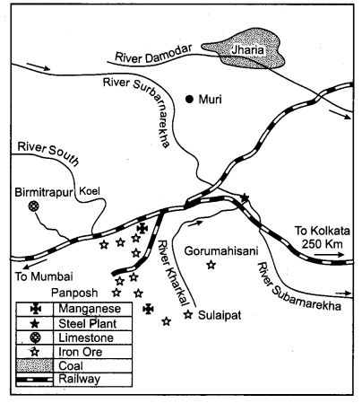
Question 10.1.
Identify and name the steel plant shown in this diagram.
Answer:
Tata Iron and Steel Plant (TISCO).
Question 10.2.
Name the mining fields which supply coal and limestone to this plant.
Answer:
Coal is brought from Jharia and Bokaro coal fields. Limestone comes from Birmitrapur.
Question 10.3.
Mention the source of water for this plant.
Answer:
Rivers Subarnarekha and Kharkoi provide water to the plant.
Question 11.
“The promotion of the use of non-conventional sources of energy in India is the need of the hour.” Support the statement. [3]
Answer:
The use of fossil fuels like coal and petroleum results in environmental problems. Hence the use of alternative source of energy has become more important in India for the following reasons :
- The alternative sources of energy like solar energy, wind energy etc. are renewable. Hence, they are sustainable and will never run out.
- The renewable resources being derived from natural and available resources reduces the cost of operation.
- These alternative energy resources produce little or no harmful pollutants like carbon dioxide etc. and are thus more environment friendly.
Question 12.
“Many of the modern towns in India were developed during the period of British domination.” Substantiate the statement. [3]
Answer:
The British and other Europeans have developed a number of towns in India. They first
developed some trading ports such as Mumbai, Chennai, Kolkata, Surat, Daman, Goa, Puducherry, etc. for the ease of trade and commerce. Gradually they established their administrative centres, hill towns, summer resorts etc. They developed military cantonments or camp towns and also health resorts. Towns based on modern industries also evolved after 1850, e.g., Jamshedpur. After independence, a large number of towns have been developed as administrative headquarters, e.g. Chandigarh, Bhubaneshwar, Gandhinagar, Dispur, etc. and industrial centres such as Durgapur, Bhilai, Sindri, Barauni. etc., Some old towns also developed as satellite towns around metropolitan cities such as Ghaziabad, Rohtak, Gurgaon around Delhi. With increasing investment in rural areas, a large number of medium and small towns have developed all over the country.
Question 13.
“The urban waste should be properly treated as a resource for various needs of mankind.” Explain the values that can help in changing the urban waste into resources. [3]
Answer:
The value that can help in changing the urban waste into resources are :
(i) Creating Awareness: Societies should be made aware for using the urban waste in the productive use for example—kitchen and garden waste can be converted into compost. Sewage can be used to produce biogas.
(ii) To evolve the new Techniques : Innovative production techniques should be used such as waste exchanges process in which the waste product of one process becomes the raw material for a next process. Waste exchange process will help to use, waste which is difficult to eliminate. For example in the manufacturing of soap, Glycerin will be extracted from the waste.
(iii) Caring attitude towards Urban Waste : The urban waste should be treated with care as scraps can be re-used at the beginning of the manufacturing process so that they do not become a waste product. For example, paper mills use the damaged rolls to the beginning of the production line, the metal and plastic items, can be re-incorporated into new products.
Question 14.
What is ‘demographic cycle’ ? Describe three stages of ‘demographic transition theory.’
[3 + 2 = 5]
Answer:
Demographic transition theory can be used to describe and predict the future population of any area. The theory tells us that population of any region changes from high births and high deaths to low births and low deaths as society progresses from rural agrarian and illiterate to urban industrial and literate society. These changes occur in stages which are collectively known as the demographic cycle.
The first stage has high fertility and high mortality because people reproduce more to compensate for the deaths due to epidemics and variable food sup-ply. The population growth is slow and most of the people are engaged in agriculture where large families are an asset. Life expectancy is low, people are mostly illiterate and have low levels of technology. The population remains stationary. Two hundred years ago all the countries of the world were in this stage. Fertility remains high in the beginning of second stage but it declines with time. This is accompanied by reduced mortality rate. Improvements in sanitation and health conditions lead to decline in mortality. Because of this gap the net addition to population is high. So the population expands. Thus this stage is also known as the Expanding stage.
In the last stage, both fertility and mortality decline considerably. The population is either stable or grows slowly. The population becomes urbanised, literate and has high technical know how and deliberately controls the family size.
Question 15.
Differentiate between Nomadic herding and commercial livestock rearing, stating any five points of distinction. [5 × 1 = 5]
Answer:
| Nomadic herding | Commercial Live-Stock rearing |
|
|
Question 16.
What is ‘tourism’ ? Analyse any four tourist attractions in the world. [1 + 4 = 5]
Answer:
Tourism is travel undertaken for purposes of recreation rather than business. Tourism is developed in areas having suitable climate, picturesque landscape or are important religious, cultural or centre of history and art.
There are various tourist attractions all over the world and they are important for their own unique features :
- Warm, sunny weather account for beach holidays. This is one of the main reasons for the importance of tourism in southern Europe and the mediterranean lands. Goa, Maldives etc. are famous for their luxuriant sea beaches.
- Places like the Himalayas in India, the Alps in Europe are known for their natural beauty and attract tourists from all over the world for various adventure sports and mountain climbing.
- Places like Mecca, Varanasi, Jaipur, Jerusalem
are important tourist attractions as they have a rich heritage and every year tourists visit these places for pilgrimage. - Places like museums in France and London attract a lot of people because of rich variety of knowledge and information they present, and their glorious history and artefacts.
Question 17.
“The Suez and the Panama canals are two vital man-made navigation canals which serve as gateways of commerce for both the eastern and western worlds.” In the light of this statement explain the economic significance of these two canals. [21/2 + 21/2 = 5]
Answer:
This canal had been constructed in Egypt between Port Said in the North and Port Suez in the South linking the Mediterranean Sea and the Red Sea. Suez Canal decreases the road between Europe and South Asia from 16000 km (travel from the Cape of Good Hope) to 10000 km.
Suez Canal helps especially to developed countries to trade with developing ones. Most of developing countries are placed in Middle East and Asia. Therefore, developed European countries open up factories in borders of those who have cheap labour force and land. Moreover finished products could be easily transported from ports in south Asia to Europe or United States.
This Canal strengthens the power of Egypt in world economy. With the taxes from the ships which use the Suez canal, Egyptian economy keeps growing day- by-day. The required labour force comes from Egypt and reduces the unemployment rate in the country.
Suez canal gives Egypt a strategic power to affect world trade by having a transportation road between developing and developed countries.
The Panama canal connects the Atlantic Ocean in the East to the Pacific Ocean in the West.
It shortens the distance between New York and San Francisco by 13,000 km by sea. The canal permits shippers of commercial goods, ranging from automobiles to grain, to save time and money by transporting cargo more quickly. Prior to the completion of the canal, a ship sailing between ports in New York and San Francisco had to sail around Cape Horn, which took 67 days.
Question 18.
Explain why the causes of male and female migration are different in India. Find out the environmental consequences of migration. [2 + 3 = 5]
Answer:
The reasons for migration of males and females are different. For example, work and employment is the main cause for male migration while it is very less for the females. Contrary to this, about 65 per cent of females move out from their parental houses following their marriage. This is the most important cause in the rural areas of India except in Meghalaya where reverse is the case.
Overcrowding of people due to rural-urban migration has put pressure on the existing social and physical infrastructure in the urban areas. This ultimately leads to unplanned growth of urban settlement and formation of slums shanty colonies. Apart from this, due to over-exploitation of natural resources, cities are facing the acute problem of depletion of ground water, air pollution, disposal of sewage and management of solid wastes.
Question 19.
“Erratic monsoon’ and ‘Indebtedness’ are the major problems of Indian agriculture.” Suggest and explain the measures to overcome these problems. [2 + 3 = 5]
Answer:
Agriculture in India is affected by uncertain, unreliable and erratic monsoon rainfall. India cannot achieve sustained progress in agriculture unless and until more than half of the cropped area is brought under assured irrigation. Expansion of irrigation has played a very crucial role in enhancing agricultural output in the country. It provided basis for introduction of modern agricultural technology such as high yielding varieties of seeds, chemical fertilizers, pesticides and farm machinery. The net irrigated area in the country has increased from 20.85 to 54.66 million hectare over the period 1950-51 to 2000-01. Over these 50 years, area irrigated more than once in an agricultural year has increased from 1.71 to 20.46 million hectare.
The main suppliers of money to the farmer are the money-lenders, traders and commission agents who charge high rate of interest and purchase the agricultural produce at very low price. The inputs of modern agriculture are very expensive and are often out of reach of the marginal and small farmers as they have very meagre or no saving to invest in agriculture. All India Rural Credit Survey Committee showed that in 1950-51 the share of money lenders stood at as high as 68.6 per cent of the total rural credit and in 1975-76 their share declined to 43 per cent of the credit needs of the farmers. This shows that the money lender is losing ground but is still the single largest contributor of agricultural credit.
Rural credit scenario has undergone a significant change and institutional agencies such as Central Cooperative Banks, State Cooperative Banks, Commercial Banks, Cooperative Credit Agencies and some Government Agencies are extending loans to farmers on easy terms. There has been a steady increase in the flow of institutional credit to agriculture over the years.
Question 20.
Why is the distribution of roads not uniform in India ? Explain with examples. [1 × 5 = 5]
Answer:
The factors for the uneven distribution of roads in India are :
Nature of Terrain: Mountains, plateaus and plains.
Construction of roads is easy and cheaper in the level plain areas, while it is difficult and costly in hilly and plateaus areas. The distribution of roads is not uniform in the country. Density of roads varies from only 10.48 km in Jammu and Kashmir to 387.24 km in Kerala with a national average of 75.42 km. The
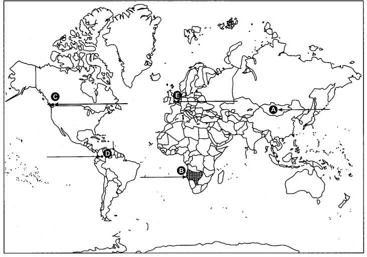
Question 21.
Five geographical features shown on the given political outline map of the world as A, B, C, D and E. Identify these features with the help of the information given below and write their correct names on the lines marked near them:
Answer:
[5 × 1 = 5]
(A) The country with lowest density of population in Asia.
(B) An area of nomadic herding.
(C) A major sea port
(D) An international airport
(E) A mega city
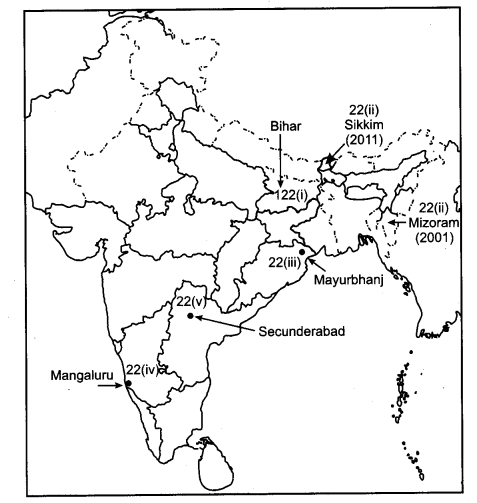
Question 22.
Locate and label the following on the given political outline map of India with appropriate symbols. [5 × 1 = 5]
(i) The state having the highest density of population (2011).
(ii) The state with smallest rural population.
(iii) Mayurbhanj—an iron ore mining area.
(iv) An oil refinery in Karnataka state.
(v) The headquarter of South Central Railway Zone.
Answer:
CBSE Previous Year Question Papers Class 12 Geography 2016 Delhi Set – II
Note : Except for the following questions, all the remaining questions have been asked in previous set.
Question 1.
Why is sex ratio in some European countries recorded favourable to females ? Give one reason. [1]
Answer:
Sex ratio is favourable for women in some European countries is attributed to better socio-economic status of women, and an excessively male-dominated out-migration.
Question 3.
Define the term ‘technopolies.’ [1]
Answer:
Technologically advanced cities, or cities heavily involved in mechanised manufacture of goods, self-sustained and highly specialized are called technologies.
Question 4.
How is ‘Barter system’ practiced among various tribal communities in the world ? [1]
Answer:
The initial form of trade in primitive societies was the barter system, where direct exchange of goods took place. In the olden times, before paper and coin currency came into being, rare objects with very high intrinsic value served as money, like, flintstones, obsidian, cowrie shells, timer’s paws, whale’s teeth, dogs teeth, skins, furs, cattle, rice, peppercorns, salt, small tools, copper, silver and gold in exchange of commodities.
Question 5.
Name the Union territory of India having lowest density of population as per 2011 census. [1]
Answer:
Andaman and Nicobar islands have the least density of population.
Question 6.
Name the major seaport which has been developed to relieve the pressure at Chennai seaport. [1]
Answer:
Ennore Sea-port has been constructed to relieve the pressure at Chennai port.
Question 9.
Study the diagram given below and answer the questions that follow : [3 × 1 = 3]
Question 9.1.
Identify and name the pattern by rural settlement.
Answer:
Circular pattern.
Question 9.2.
In which type of areas do we find such settlement patterns ?
Answer:
Circular villages develop around lakes, tanks or ponds.
Question 9.3.
Give an important characteristic of this type of settlement pattern.
Answer:
Village is planned in such a way that the central part remains open and is used for keeping the animals to protect from wild animals.
Question 11.
Explain the importance of irrigation for agriculture in India. [3 × 1 = 3]
Answer:
Importance of Irrigation:
- Control of Drought and Famines : Insufficient, uncertain and irregular rain causes uncertainty in agriculture. Even during monsoon , the rainfall is scanty and undependable in many parts of the country. Sometimes the monsoon delayed considerably while sometimes they cease prematurely. This pushes large areas of the country into drought conditions. With the help of irrigation, droughts and famines can be effectively controlled.
- Higher Productivity on irrigated Land : Productivity on irrigated land is considerably more than the productivity on un-irrigated land.
- Multiple Cropping Possible : Provision of irrigation facilities can make possible the growing of two or three crops in a year in most areas of the country. This will considerably enhance agriculture production and productivity.
- Role in New Agricultural Strategy : The successful implementation of the high yielding programme enhances agricultural production in a great intent. This has been made possible due to the expansion of irrigation facilities.
Question 15.
Differentiate between co-operative farming and collective farming; stating any five points of distinctions. [5]
Answer:
(i) Cooperative farming refers to an organization in which each member-farmer remains the owner of his land individually but farming is done jointly. Profit is distributed among the member-farmers in the ratio of land owned by them. In socialist or communist countries, such as the former Soviet Union, a collective is a cooperative association of farmers who work on land owned by the state but who own most of their own farm implements.
(ii) Co-operative farming refers to pooling of farming resources such as fertilizers, pesticides, farming equipments such as .tractors. It however generally excludes pooling of land unlike in collective farming where pooling of land is also done. In collective farming the farmers pool in all their resources like land, livestock and labour.
(iii) A group of farmers form a co-operative society by pooling in their resources voluntarily for more efficient and profitable farming. Collective farming is based on social ownership of the means of production and collective labour.
(iv) In co-operative farming the farmers get assistance , to procure all important inputs of farming, sell the products at the most favourable terms and help in processing of quality products at cheaper rates. In case of collective farming yearly targets were set by the government and the produce was also sold to the state at fixed prices. Produce in excess of the fixed amount was distributed among the members or sold in the market.
(v) Co-operative movement originated over a century ago and has been successful in many Western European countries like Denmark, Netherlands, Belgium, Sweden,. Italy etc. This type of farming was introduced in former Soviet Union under the socialist regime which was adopted by the socialist countries.
Question 19.
“Low productivity’ and ‘Fragmentation of land holdings’ are the major problems of Indian agriculture.” Suggest and explain measures to overcome these problems. [2 + 3 = 5]
Answer:
The pressure of increasing population and the practice of dividing land equally among the heirs has caused excessive sub divisions of farm holdings. Consequently, the holdings are small and fragmented. The small size of holdings makes farming activity uneconomical and leads to social tension, violence and discontentment. Consolidation of village lands and cooperative farming will ease the burden of fragmented land holdings.
With deforestation the natural fertility of soil has been drying out. Lack of material resources and ignorance of scientific knowledge have further depleted the soils of the natural fertility. This is a serious problem which can be solved by using manures and fertilizers. If has been felt that organic manures are essential for keeping the soil in good health. The government also has given high incentive especially in the form of heavy subsidy for using chemical fertilizers. Easy availability of labs for soil testing and proper irrigation facilities are suggested.
CBSE Previous Year Question Papers Class 12 Geography 2016 Delhi Set – III
Note : Except for the following questions, all the remaining questions have been asked in previous set.
Question 1.
“In some countries of the world the sex ratio is unfavourable to women.” Give one reason. [1]
Answer:
One of the reasons for unfavourable sex ratio for women in some countries could be lower socio-economic status of women in these areas resulting in female foeticide, female infanticide and domestic violence against women.
Question 3.
“Why is the large integrated steel industry located close to the source of raw material ? Give one reason. [1]
Answer:
The large integrated steel plants use bulky and weight-losing raw material (ores). Hence they are located close to the sources of raw material to reduce transport cost.
Question 4.
How is the importance of a sea-port judged ? [1]
Answer:
The importance of a port is judged by the size of cargo and the number of ships handled. The quantity of cargo handled by a port is an indicator of the level of development of its hinterland.
Question 5.
Name the state of India having lowest density of population as per 2011 census. [1]
Answer:
According to 2011 census, Arunachal Pradesh has the lowest density of population.
Question 6.
Define the term ‘hinterland’. [1]
Answer:
Hinterland means the land behind a port, in shipping usage. A port’s hinterland is the area that it serves, both for imports and for exports.
Question 9.
Study the diagram given below and answer the questions that follow : [3 × 1 = 3]
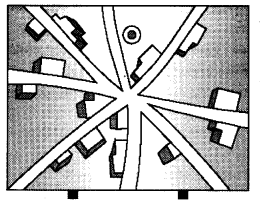
Question 9.1.
Identify and name the pattern of settlement.
Answer:
Spir-like pattern.
Question 9.2.
In which areas do we find such rural settlement patterns ?
Answer:
Largely in plains and valleys.
Question 9.3.
Give one feature characteristic of this type of settlement pattern.
Answer:
The settlement takes place along all the roads that converge at a point.
Question 11.
Explain the importance of Indira Gandhi canal for providing water for irrigation in the Canal Command area. [3 × 1 = 3]
Answer:
Indira Gandhi canal, previously known as the Rajasthan canal, is one of the largest canal systems in India. Introduction of canal irrigation has brought about a large scale transformation in the agricultural economy of the region.
- It has provided water for drinking.
- Normadic tribes have now settled.
- Due to irrigation, it is possible to grow various crops like cotton, wheat etc.,
- Plantation of trees has also taken place.
Question 15.
Differentiate between mixed farming and dairy farming; stating any five points of distinction. [5 × 1 = 5]
Answer:
The differences are as follows :
- The use of a single farm for multiple purposes, as the growing of cash crops or the raising of livestock is called as mixed farming. Dairy farming involves the management of dairy cows and milking operations to ensure maximum milk production.
- In mixed farming a variety of crops are grown but in dairy farms only fodder crops are grown. Mixed farming is capital intensive but dairy fanning is both capital as well as labour intensive.
- The crops associated with mixed farming are wheat, barley, oats, rye, maize, fodder and root crops. Fodder crops are an important component of mixed farming. Dairy farms produce milk and milk related products.
- In mixed farming equal emphasis is laid on crop cultivation and animal husbandry. In dairy farming a greater emphasis is placed on the improvement
of herds, scientific management of livestock, maintenance of sheds and storage of dairy products, - Mixed farming is largely developed in European countries but dairy farming is developed largely in Denmark, Germany, Eastern part of North America, New Zealand and Southeastern part of Canada.
Question 19.
Explain how the ‘modern agricultural technology and ‘expansion of irrigation’ played a crucial role in enhancing agricultural output in India. [2 + 3 = 5]
Answer:
There has been a significant increase in agricultural output due to improvement in technology and expansion of irrigation :
(i) Production and yield of many crops such as rice and wheat has increased at an impressive rate. Among the other crops, the production of sugarcane, oilseeds and cotton has also increased appreciably. India ranks first in the production of pulses, tea, jute, cattle and milk. It is the second largest producer of rice, wheat, groundnut, sugarcane and vegetables.
(ii) Expansion of irrigation has played a very crucial role in enhancing agricultural output in the country. It provides basis for introduction of modern agricultural technology such as high yielding varieties of seeds, chemical fertilizers, pesticides and farm machinery. The net irrigated area in the country has increased from 20.85 to 54.66 million hectare over the period 1950-51 to 2000-01. Over these 50 years, area irrigated more than once in an agricultural year has increased from 1.71 to 20.46 million hactare. This spurt of agricultural growth came to be known as ‘Green Revolution’. This also gave impetus to the development of a large number of agro-inputs, agro-processing industries and small-scale industries. This strategy of agricultural development made the country self-reliant in food grain production.