CBSE Previous Year Question Papers Class 12 Geography 2014 Outside Delhi
Time allowed : 3 hours
Maximum marks: 70
General Instructions:
- There are 22 questions in all.
- All questions are compulsory.
- Question number 1 to 7 are very short-answer questions carrying 1 mark each. Answer to each of these questions should not exceed 40
- Question numbers 8 to 13 are short-answer questions carrying 3 marks each. Answer to each of these questions should not exceed 80-100 words.
- Question numbers 14 to 20 are long-answer questions carrying 5 marks each. Answer to each of these questions should not exceed 150
- Question numbers 21 to 22 are related to identification or locating and labelling of geographical features on maps, carrying 5 marks each.
- Outline maps of the World and India provided to you must be attached within your answer-book.
- Use of templates or stencils for drawing outline maps is allowed.
** Answer is not given due to change in present syllabus
CBSE Previous Year Question Papers Class 12 Geography 2014 Outside Delhi Set – I
Question 1.
Give the meaning of ‘Age Structure’. [1]
Answer:
The age structure of a population is the distribution of people among various ages. In graphic form, age structure is portrayed by an age pyramid where relatively broad base indicates the number of children while the peak reflects the increasing likelihood of death as people age.
Question 2.
Which country has proclaimed ‘Gross National Happiness’ as the measure of a country’s progress ? [1]
Answer:
Bhutan.
Question 3.
What is the meaning of ‘Cyber-space’ ? [1]
Answer:
Cyber space is an electronic system of interlinked networks of computers, bulletin boards, etc., that is thought of as being a boundless environment providing across to information and interactive communication. It is also referred as internet.
Question 4.
Name the most important inland waterway of Germany. [1]
Answer:
The Rhine waterway.
Question 5.
Which state of India has the highest rank in Human Development Index (H.D.I.) value ? [1]
Answer:
Kerala.
Question 6.
Name the ‘urban agglomeration’ having the highest share of immigrant population in India. [1]
Answer:
Mumbai.
Question 7.
Give an example of an ancient historical town from Bihar. [1]
Answer:
Patliputra (Patna).
Question 8.
Define the term ‘watershed management’. [1]
Answer:
Watershed management is the term used to describe the process of implementing land use practices and water management practices to protect and improve the quality of the water and other natural resources within a watershed by managing the use of those land and water resources in a comprehensive manner.
Question 9.
What is ‘satellite communication’ ? [1]
Answer:
Communication via satellite is known as satellite communication. Artificial satellites are successfully deployed in earth’s orbit to connect even the remote corners of the globe with limited on-site verification. In satellite communication, signal transferring between the sender and receiver is done with the help of satellite. In this process, the signal which is basically a beam of modulated microwaves is sent towards the satellite.
Question 10.
Mention any two diseases caused by contaminated water. [1/2 + 1/2 = 1]
Answer:
Diarrhoea and cholera.
Question 11.
Explain with examples, how nature gets humanized. [3 × 1 = 3]
Answer:
Human starts interacting with physical environment with the help of technologies. With social and cultural development, human develops better and more efficient technologies. For example, in earlier era, people used to live in caves and were totally dependent on hunting of animals. They started developing their weapons from stones and other easily available materials. Later on they discovered more suitable instruments. When human starts interacting with physical environment, they start forming state of necessity rather than the state of freedom.
Question 12.
Describe any three characteristics of the last stage of ‘Demographic Transition Theory’. [3 × 1 = 3]
Answer:
- During the last stage of demographic transition, both fertility and mortality rates drop considerably.
- The population is either stable or grows at a slow rate.
- The population becomes urbanised, civilised, literate and has good knowledge about everything. They deliberately control sizes of their families.
- Thus, people are able to control their fertility and this shows that they are flexible.
Question 13.
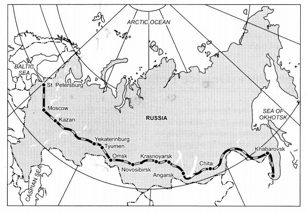
Study the map given below and answer the questions that follow : [1 +1 + 1 = 3]
Question 13.1.
Identify and name the railway line shown on the map.
Answer:
Trans-Siberian Railway.
Question 13.2.
Name the continents linked by this rail route.
Answer:
It connects Asian countries with European countries.
Question 13.3.
Explain how this railway line is helpful for the promotion of trade in this region.
Answer:
It helped Asian region to market their products in European region.
Question 14.
“The decades 1951-81 are referred to as the period of population explosion in India.” Explain the statement by giving any three reasons. [3 × 1 = 3]
Answer:
The decades 1951-1981 referred to as the period of population explosion in India due to following reasons :
- There was rapid fall in mortality rate because of improvement in living conditions.
- High fertility rate of the population in the country was pretty high.
- Improvement in transportation and communication.
- Improvement in health, sanitation and medical facilities.
Question 15.
Give the meaning of ‘dispersed settlement’. Explain any two reasons for the development of such settlements in India. [1 + 2 = 3]
Answer:
Dispersed Rural Settlement : Dispersed rural settlements are those in which houses are built far apart from each other. These settlements consist of one or two houses and cultural features such as a church or a temple binds the settlement together. Such settlements are found over hills, plateau and highlands. The reasons for the development of such settlements in India are :
- Extremely fragmented nature of the terrain and land resource of habitable areas.
- Safety of people who have to travel a long distance for basic commodities are threatened because of isolation that is why, this settlement is preferred.
Question 16.
Study the diagram given below showing the location of a major steel plant in India and answer the questions that follow : [1 + 1 + 1 = 3]
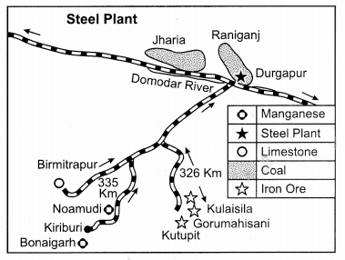
Question 16.1.
Identify and name the steel plant shown in this diagram.
Answer:
Durgapur Steel Plant
Question 16.2.
Name two coal-fields which supply coal to this plant.
Answer:
Jharia and Raniganj
Question 16.3.
Mention the source of water supply for this plant
Answer:
Damodar river.
Question 17.
“The distribution of roads in India is not uniform”. Examine the statement giving three reasons. [3 × 1 = 3]
Answer:
Distribution of road is not uniform in India due to different types of geographical features. Moreover, the volume of traffic as well as passengers also affects road networking in India. Roads become narrow and congested with broken culverts and bridges. Some roads are metalled that are well built with brick and cement whereas some are unmetalled especially in rural areas which become inaccessible during rainy seasons. The regions with rugged terrain have steep roads with many hairpin bends. For ununiformed distribution, there are certain reasons :
- Construction of roads is costlier in mountains, valleys and plateau region than plain region.
- Less population also affects construction of roads. Deserts interior most parts of the country do not require large number of roads, hence have lesser number of roads.
- The ratio of rivers, canals and other such geographical forms are higher in India. It works as a barrier in constructing roads.
Question 18.
“Most of India’s foreign trade is carried through sea routes”. Explain the statement giving three reasons. [3 × 1 = 3]
Answer:
Port plays an important role in the growth of manufacturing and mining sector. Core manufacturing sector like steel, refinery and automobiles are dependent on trade for raw materials and sale of finished products. Logistics cost plays an important role in the cost of production and hence profitability of the business as volumes of material to be transported are huge. The 12 state-owned ports (Kolkata, Paradip, Vishakhapatnam, Ennore, Chennai, Tuticorin, Kochi, New Mangalore, Mormugao, Kandla, Mumbai and Navi Mumbai) which look after about 58 per cent of India’s external trade by volume shipped by sea. With rising demand for port infrastructure due to growing imports (crude, coal) and containerization, it will be difficult for public ports to meet demand. This provides private ports with an opportunity to serve the spill-off demand from major ports and increase their capacities in line with forecasted new demand.
Question 19.
Describe any three major problems of slums in India. [3 × 1 = 3]
Answer:
The three problems faced by slum dwellers in India are :
- The areas in which they live (dilapidated houses) are overcrowded having narrow street pattern prone to serious hazards from fire.
- Lack of basic amenities like drinking water, light, and toilet facilities. They are also faced by poor ventilation, and poor hygienic conditions.
- These slums in the nearby areas breed because of pollution and thus their existence results in health hazards. Since they have no place to bathe, go to the toilet, wash their clothes, so all this daily work is done in the open causing inconvenience to the residents of the areas.
Question 20.
Explain any three social and economic values which encourage us to use more and more non- conventional sources of energy. ** [3 × 1 = 3]
Question 21.
Explain any five characteristics of ‘extensive commercial grain cultivation’ practised in the world. [5 × 1 = 5]
Answer:
Extensive commercial farming is a system of agriculture in which relatively small amounts of capital or labour investment are applied to relatively large areas of land. At times, the land is left fallow to regain its fertility.
- This commercial grain cultivation is practiced in the interior parts of semi-arid lands of the mid-latitudes.
- The size of the farm is very large, therefore entire operations of cultivation from ploughing to harvesting are mechanized.
- There is low yield per acre but high yield per person.
- It usually occurs at the margin of the agricultural system, at a great distance from market or on poor land of limited potential and is usually practiced in the tarai regions of Southern Nepal.
- Wheat is the principal crop, though other crops like corn, barley, oats and rye are also grown.
Question 22.
Define the terms ‘manufacturing’. Explain any four features of ‘small scale manufacturing’. [1 + 4 = 5]
Answer:
Manufacturing is the production of merchandise for use or sale using labour and machines, tools, chemical ari3 biological processing, or formulation. The term may refer to a range of human activities, from handicrafts to high technology but is most commonly applied to industrial production. Features of small manufacturing are :
- Simple power driver machines are used.
- The manufacturing of products is based upon the raw material available in that area.
- Semi-skilled and un-skilled labours are used.
- It raises local purchasing power.
Question 23.
Why are ports known as ‘gateways’ of international trade ? Explain any three characteristics of inland ports. [2 + 3 = 5]
Answer:
Ports are known as gateways of international trade because cargoes and travelers pass from one part of the world to another through these ports. The ports provide facilities of docking, loading, unloading and the storage facilities for cargo. Port authorities make arrangements for maintaining navigable channels, arranging tugs, and barges, and providing labour and managerial services. The importance of port is judged by the size of cargo and the number of ships handled.
Characteristics of inland ports :
- These ports are located away from the sea coast.
- They are linked to the sea through a river or a canal.
- Such ports are accessible to flat bottom ships or barges.
eg. Manchester is linked with a canal.
Phine has several ports like Mannheim, Duisburg.
Kolkata is located on the river Hooghly, a branch of river Ganga.
Question 24.
Explain any five major problems of the rural settlements in the developing countries of the world. [5 × 1 = 5]
Answer:
Problems of rural settlements in the developing countries of the world are :
- Supply of water to rural settlements in developing countries is not adequate. People in villages, particularly in mountainous and arid areas have to walk long distances to fetch drinking water.
- Water-borne diseases such as Cholera and Jaundice are common problems because of lack of safe drinking water and unhygienic conditions.
- Villages are adversely affected by the conditions of drought and flood. This in turn, affects the crop cultivation.
- Unmetalled roads and lack of modern communication network causes difficulties in providing emergency services during floods.
- It is also difficult to provide adequate health and educational infrastructure for large rural population. The problem is particularly serious where houses are scattered over a large area.
Question 25.
Analyse any five major problems of Indian agriculture. [5 × 1 = 5]
Answer:
The major problems of Indian agriculture are :
- Dependency on monsoon due to insufficient irrigation system is major drawbacks of Indian agriculture system.
- The yield of crops in India is very low. Less productive seeds are used for agriculture instead of hybrid seeds.
- Poor economic system and insuffcient infra-structural developments of Indian villages also work as a barrier for agricultural development in India.
- The employment of scientific technique, especially in America and Russia, has achieved tremendous progress. In the first place, machines have superseded manual labour. That means a larger acreage is brought under cultivation in more effcient manner. ,
- All this needs far-sighted planning. When the determined efforts are made to modernize their ownership of land is restored to the cultivators, and outlook, agriculture in India will fourish much more.
Question 26.
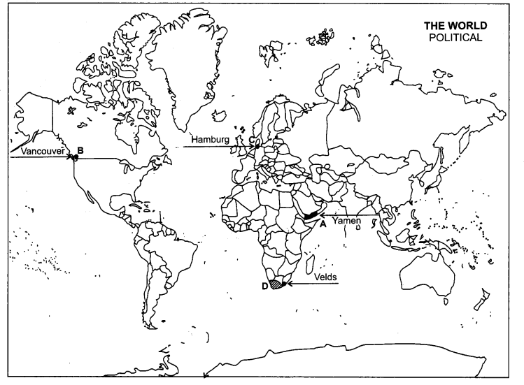
Question 26.1.
In the given political outline map (on page) of the world, four features A, B, C and D have been shown. Identify these features with the help of the information given below and write their correct names on the lines drawn near them : [4 × 1/2 = 2]
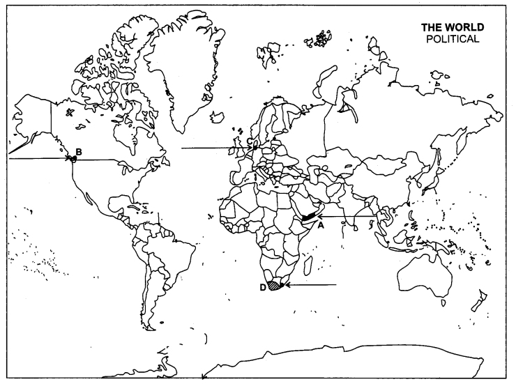
(A) The country with the highest growth rate of population (1995-2000) in Asia.
(B) A terminal station of Trans-Canadian railway line.
(C) An important sea port.
(D) An area of extensive commercial grain farming.
Question 26.2.
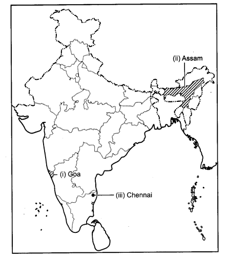
On the given political outline map (on page) of India, locate and label the following with appropriate symbols :
(i) The state having the highest percentage of urban population.
(ii) The leading state in the production of tea.
(iii) The international airport in Tamil Nadu.
Answer:
26.1
26.2
CBSE Previous Year Question Papers Class 12 Geography 2014 Outside Delhi Set – II
Note : Except for the following questions, all the remaining questions have been asked in previous set.
Question 2.
Mention any two pillars of human development. [1/2 + 1/2 = 1]
Answer:
Equity, sustainability, productivty and empowerment.
Question 5.
Who are ‘marginal workers’ in India ? [1]
Answer:
Marginal worker is a worker who works for less than 183 days (or six months) in a year.
Question 12.
Describe any three characteristics of the first stage of ‘Demographic Transition Theory’. [3]
Answer:
Characteristics of the first stage of demographic transition theory are :
- High fertility and high mortality rate,
- Slow growth in population,
- High rate of illiteracy.
Question 14.
Explain the main reasons for the migration of males and females separately in India.
[11/2 + 11/2 = 3]
Answer:
In India, people migrate from rural to urban areas mainly due to poverty, high population pressure on the land, lack of basic infrastructural facilities like health care, education, etc. Work and employment are the main causes for male migration (38%) while it is only 3% for the females. Contrary to this, about 65% of females move out from their parental houses after their marriage. This is the most important cause in the rural area of India.
Question 17.
Describe any three advantages of pipelines as a means of transport in India. [3 × 1 = 3]
Answer:
Advantages of pipelines as a means of transport in India, are :
- It is a safe and reliable mode of transport system.
- It is an economical and dependable mode of transport system particularly to the sensitive and strategic areas.
- It provides a long term infrastructural option.
Question 21.
Define the term ‘mixed farming’. Explain any four characteristics of mixed farming practiced in the world. [1 + 4 = 5]
Answer:
Mixed farming is an agrarian system that mixes arable farming with the raising of livestock. When on a farm along with crop production, some other agriculture based practices like poultry, dairy farming or bee keeping etc., are adopted, and then this system of farming is known as mixed farming. It is dominant system in Europe, where most farms have a mixture of fields and pastures. Some characteristics are :
- It offers highest return on farm business, as the by-products of farm are properly utilized.
- It provides work throughout the year.
- Efficient utilization of land, labour, equipment and other resources.
- The crop by products such as straw, forage, fodder etc., is used for feeding of livestock and in return they provide milk and other products.
Question 25.
Explain the term ‘cropping intensity’. Describe the three cropping seasons in India. [2 + 3 = 5]
Answer:
Cropping intensity means that a higher portion of the net area is being cropped more than once during one agricultural year. This also implies higher productivity per unit of arable land during one agricultural year.
Cropping seasons in India :
Kharif season:
- This season depends upon south-west monsoon.
- This season falls between June to September.
- Major crops — Rice, jowar, maize, bajra, etc.
Rabi Season:
- This season begins with onset of winter.
- The period of this season is from October to March.
- Major crops—Wheat, gram, mustard, barley, etc.
Zaid Season :
(i) It is a short duration between Rabi and Kharif. Major crops of the season are—Watermelon, fruits, vegetables, fodder crops.
CBSE Previous Year Question Papers Class 12 Geography 2014 Outside Delhi Set – III
Note : Except for the following questions, all the remaining questions have been asked in previous set.
Question 1.
Give the meaning of ‘sex-ratio’. [1]
Answer:
The ratio between the number of women and the men in the population is called as the sex ratio. In India sex ratio is calculated by using this formula:
![]()
Question 6.
Define the term ‘poverty’. [1]
Answer:
A state or condition in which a person or community lacks the financial resources and essentials to enjoy a minimum standard of life and well being that’s considered acceptable in society. Poverty status in the United States is -assigned to people that do not meet a certain threshold level set by the Department of Health and Human Services.
Question 12.
Describe any three characteristics of the second stage of ‘Demographic Transition Theory’. [3 × 1 = 3]
Answer:
The three characteristics of the second stage of ‘Demographic Transition Theory’ are :
- Fertility remains high in the beginning of second stage, but it declines with time.
- Improvement in sanitation leads to reduce in mortality rate,
- Better health conditions bring about decline in mortality due to which the net addition to population is high.
Question 14.
Explain the main aspects of the ‘National Youth Policy’ of Government of India launched in 2003. [3]
Answer:
The National Youth Policy of Government of India was launched in 2003. Its main aspects were:
- It stresses on all-round improvement of the youth and adolescent enabling them to shoulder responsibilities towards constructive development of the country.
- The thrust of this policy is youth empowerment in terms of their effective participation in decision-making and carrying the responsibility of an able leader.
- Special emphasis was given in empowering women and girl child to bring parity in the male-female status.
Question 17.
Explain any three characteristics of ‘State Highways’ in India. [3 × 1 = 3]
Answer:
Three characteristics of State Highways in India are :
- These are constructed and maintained by state governments.
- They join the state capitals with district headquarters and other important towns. These roads are connected to the National Highways.
- These constitute 4 per cent of total road length in the country
Question 24.
Explain any two socio-cultural and any three environmental problems of urban settlements of the world. [3]
Answer:
Socio-cultural Problems : Cities in the developing countries suffer from several social ills.
- Inadequate social infrastructure and basic facilities is due to lack of financial resources and over-population in the cities.
- The available educational and health facilities remain beyond the reach of the urban poor.
- Cities suffer from poor health conditions.
- Lack of employment and education tends to aggravate the crime rates.
- Selective male migration to the urban areas distorts the sex ratio in these cities.
Environmental Problems :
- The large urban population in developing countries uses and disposes off a huge quantity of water and all types of waste materials.
- Many cities of the developing countries do not provide the minimum required quantity of drinkable water and water for domestic and industrial uses.
- An improper sewerage system creates unhealthy conditions.
- Massive use of traditional fuel in the domestic as well as the industrial sector severely pollutes the air.
- The domestic and industrial wastes are either let into the general sewerages or dumped without treatment at unspecified locations.
- Huge concrete structures of buildings create heat in the city environment.
Question 25.
Define the term ‘Net Sown Area’. Explain any two characteristics each of ‘dry land farming’ and ‘wetland farming’. [1 + 2 + 2 = 5]
Answer:
The physical extent of land on which crops are sown and harvested is known as net sown area. It represents the total area sown with crops. Area shown more than once in the same year is counted only once.
On the basis of adequacy of soil moisture during the cropping season the farming is divided into two categories i.e., dry land farming and wetland farming.
Characteristics of ‘dry land farming’:
- It is largely confined to the regions having annual rainfall less than 75 cm.
- These regions grow hardly drought resistant crops such as ragi, bajra, moong, gram and guar.
- It uses various soil moisture conservation and rainwater harvesting techniques.
Characteristics of ‘wetland farming’:
- It is largely confined to the regions where rainfall is in excess of the soil moisture requirement of plant during rainy season.
- Such regions may face flood and soil erosion hazards.
- These areas grow various water intensive crops such as rice, jute, and sugarcane and practice aquaculture in the fresh water bodies.