Practicing the CBSE Sample Papers for Class 12 Geography with Solutions Set 7 allows you to get rid of exam fear and be confident to appear for the exam.
CBSE Sample Papers for Class 12 Geography Set 7 with Solutions
Time : 3 Hours
Max. Marks : 70
General Instructions:
- Question paper is divided into 4 sections A, B, C & D
- In section A question number 1 to 17 are MCQ-type questions.
- In section B question number 18-23 are SA-type questions (80-100 words). Question 18 & 19 are Source based questions.
- In section C question number 24 to 28 are Long Answer based questions (120-150 words).
- In section D question number 29 & 30 are Map based questions having 5 sub parts.
Section – A (17 Marks)
Question 1.
Which one of the following Railways is considered an engineering marvel? [1]
(a) Konkan Railway
(b) South Western Railway
(c) Central Railway
(d) North Eastern Railway
Answer:
(d) Both (a) and c.
Question 2.
Arrange the following carriers of load from the earliest to the modern. [1]
i. Carts and wagons
ii. Palanquin
iii. Steam engine
iv. Humans
Choose the correct option.
(a) i, iv, iii, ii
(b) iv, ii, i, iii
(c) ii, iii, iv, i
(d) iii, i, iv, ii
Answer:
(b) iv, ii, i, iii
Question 3.
Mixed farming is found in the _______ parts of the world. [1]
(a) less developed
(b) underdeveloped
(c) developing
(d) highly developed
Answer:
(d) highly developed
![]()
Question 4.
Industries producing breads and biscuits, tea, soaps and toiletries, paper for writing, televisions, etc., are _______. [1]
(a) secondary industries
(b) consumer-based industries
(c) consumer
(d) traditional industries
Answer:
(b) consumer-based industries
Question 5.
Which of the following is correctly matched? [1]
| (a) Social Geography | Geography of tourism |
| (b) Political Geography | Electoral Geography |
| (c) Economic Geography | Urban/ Rural Planning |
| (d) Settlement Geography | Behavioural Geography |
Answer:
| (b) Political Geography | Electoral Geography |
Question 6.
Which of the following is not correctly matched? [1]
| (a) Medical Geography | Epidemology |
| (b) Geography of Resources | Resource Economics |
| (c) Gender geography | Women’s Studies |
| (d) Geography of well-being | Political Studies |
Answer:
| (d) Geography of well-being | Political Studies |
Question 7.
Which one of the following is not a type of degraded land caused by natural as well as human factors? [1]
(a) Coastal sands
(b) Marshy areas
(c) Waterlogged areas
(d) Land affected by salinity
Answer:
(a) Coastal sands
Question 8.
Solid wastes cause health hazards through: [1]
(a) creation of obnoxious smell,
(b) harbouring of flies and rodents
(c) carriers of diseases like typhoid, diphtheria, diarrhoea, malaria and cholera
(d) All of the above
Answer:
(d) All of the above
Question 9.
Name the newly developed port of India which developed to revive Mumbai port: [1]
(a) Kandla
(b) Jawaharlal Nehru
(c) Chennai
(d) Kolkata
Answer:
(b) Jawharlal Nehru
Question 10.
Which among the following is correct about the first Asia’s Cross country pipeline? [1]
(a) Assam tp Baruni in Bihar
(b) Assam’to Kanpur
(c) Baruni to Kanpur
(d) Ankleshwar to Koyali
Answer:
(a) Assam to Baruni in Bihar
![]()
Question 11.
“The assessment, efficient use and conservation of water are necessary to ensure development”. Identify the values enshrined in the statement. [1]
I. Sustainable development
II. Social awareness
III. Environmental destruction
(a) Only I
(b) Only II
(c) Only III
(d) Both I and II
Answer:
(d) Both I and II
Question 12.
Which of the following States registered the lowest growth rate of 9.4%? [1]
(a) Kerala
(b) Karnataka
(c) Tamil Nadu
(d) Andhra Pradesh
Answer:
(a) Kerala
Question 13.
Assertion: The development of railways in the nineteenth century, had a great impact on various sectors in the USA.
Reason: It opened up continental interiors for commercial grain farming, mining and manufacturing in the USA. [1]
(a) Both assertion and reason are true and reason is the correct explanation of assertion.
(b) Both assertion and reason are true but reason is not the correct explanation of assertion.
(c) Assertion is true but reason is false.
(d) Assertion is false but reason is true.
Answer:
(a) Both assertion and reason are true and reason is the correct explanation of assertion.
Question 14.
Assertion (A): The backwaters (kadal) of Kerala has special significance in Inland Waterway.
Reason (R): The famous Nehru Boat Race (Vallamkali) is held in the backwaters. [1]
(a) Both assertion and reason are true and reason is the correct explanation of assertion.
(b) Both assertion and reason are true but reason is not the correct explanation of assertion.
(c) Assertion is true but reason is false.
(d) Assertion is false but reason is true.
Answer:
(b) Both assertion and reason are true but reason is not the correct explanation of assertion.
Read the passage and answer any three of the questions that follow:
Cyberspace: Internet
Cyberspace is the world of electronic computerized space. It is encompassed by the Internet such as the World Wide Web (www). In simple words, it is the electronic digital world for communicating or accessing information over computer networks without physical movement of the sender and the receiver. It is also referred to as the Internet. Cyberspace exists everywhere. It may be in an office, sailing boat, flying plane and virtually anywhere. The speed at which this electronic network has spread is unprecedented in human history.
There were less than 50 million Internet users in 1995, about 400 million in 2000 A.D. and over two billion in 2010. In the last few years there has been a shift among global users from USA to the developing countries. The percentage share of USA has dropped from 66 in 1995 to only 25 in 2005. Now the majority of the world’s users are in USA., UK., Germany, Japan, China and India.
As billions use the Internet each year, cyberspace will expand the contemporary economic and social space of humans through e-mail, e-commerce, e-leaming and e-govemance. Internet, together with fax, television and radio, will be accessible to more and more people cutting across place and time. It is these modem communication systems, more than transportation that has made the concept of global village a reality.
Question 15.
Which of these statements is/are true for cyberspace? [1]
(a) It is the world of electronic computerised space.
(b) It is encompassed by the Internet such as the World Wide Web (www).
(c) Itis the electronic digital world for communicating or accessing information over computer networks.
(d) All of the above
Answer:
(d) All of the above
Question 16.
‘In the last few years there has been a shift among global users from U.S.A to the developing countries.’ In which developed/developing countries do you now find majority of the world’s Internet users? [1]
Choose the correct set of countries from the options below.
(a) USA, China, France, India, Bangladesh
(b) USA, UK, Germany, Japan, China and India
(c) UK, Germany, Japan, Pakistan and India
(d) USA, Germany, Japan, Bangladesh and India
Answer:
(b) USA, UK, Germany, Japan, China and India
Question 17.
How many Internet users were there by 2010, at the global level? [1]
(a) Less than 50 million users
(b) About 400 million users
(c) Around one billion
(d) Over two billion
Answer:
(d) Over two billion
![]()
Section – B (18 Marks)
Question 18.
Read the Case Study given below and answer the questions that follow: [3]
At Singareni, Canaries to miners’ rescue
Singareni collieries, the country’s premier coal production company, still uses canaries to detect the presence of deadly carbon monoxide in underground mines. Miners collapse and often die even if small quantities of the highly poisonous CO are present in the air. Though miners speak lovingly of the canaries, the underground experience is not at all pleasant for the birds.
When lowered into mines with CO presence, the birds show distress symptoms such as ruffling of feathers, pronounced chirping and loss of life. These reactions occur even if 0.15 per cent of CO is present in the air. If the content is 0.3 per cent the bird shows immediate distress and falls off its perch in two to three minutes. A cage of birds is a good indicator in air containing more than 0.15 per cent CO, said a coal miner.
The sophisticated hand-held CO detectors introduced by the company can detect CO concentrations from as low as 10 ppm to as high as 1,000 ppm. But despite this, the miners trust the birds, who have saved the lives of several of their predecessors. Deccan Chronicle, 26.08.2006
(i) Which premier coal production company still uses canaries to detect the presence of deadly carbon monoxide in underground mines?
Answer:
Singareni collieries
(ii) Why the underground experience is not at all pleasant for the birds.
Answer:
When lowered into mines with CO presence, the birds show distress symptoms such as ruffling of feathers, pronounced chirping and loss of life.
(iii) What is the amount that sophisticated hand-held CO detectors can measure CO concentrations?
Answer:
The sophisticated hand-held CO detectors introduced by the company can detect CO concentrations from as low as 10 ppm to as high as 1,000 ppm.
Question 19.
Study the given data and answer the following questions: [3]
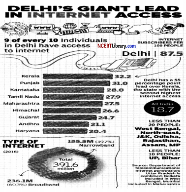
(i) Why does Delhi tops the list of internet users in India?
Answer:
Delhi is the home to the largest internet population in India because Delhi has the highest rate of urbanisation (in union territory) in India.
(ii) Where does India stand in the number of internet subscribers, globally?
Answer:
India ranks at the 2nd position in the number of internet subscribers across the world with 833.71 million users, which are less than China only.
(iii) What is ‘Digital India’?
Answer:
Digital India is a flagship campaign launched by the Government of India with a wish to transform India into a digitally empowered economy by making electronically available and improved online infrastructure and internet connectivity.
Question 20.
Write a short note on pipelines.
OR
List the various steps for better urban transport solution. [3]
Answer:
Pipelines are used extensively to transport liquids and gases such as water, petroleum and natural gas for an uninterrupted flow. Water supplied through pipelines is familiar to all. Cooking gas or LPG is supplied through pipelines in many parts of the world. Pipelines can also be used to transport liquidities coal. In New Zealand, milk is being supplied through pipelines from farms to factories.
OR
For better urban transport system, the following can be adopted:
1. Mass rapid transit (MRT)
2. Improved public bus service
3. Expressways
4. Car pool
5. Higher parking fees
6. Government measures like odd-even car system to regulate traffic flow.
Question 21.
What are three characteristics of last stage of Demographic Transition Theory? [3]
Answer:
In the last stage of demographic transition theory, both fertility and mortality decline considerably. Its characteristics features are as follows:
1. It is the stage of stable population.
2. It is also the indicator of slow population growth.
3. It also indicates that humans are extremely flexible and are able to adjust their fertility.
Question 22.
What factors are responsible for different types of rural settlements in India?
OR
Give two characteristics of urban settlements in India. How are cities connected to rural settlements? [3]
Answer:
Different types of rural settlements in India are caused by a variety of circumstances and environments.
They are as follows:
1. Physical features- nature of terrain, altitude, climate and availability of water.
2. Cultural and ethnic factors- social structure, caste and religion.
3. Security factors- defense against thefts and robberies.
OR
Urban settlements are often smaller and more compact, and they perform a wide range of nonagricultural, commercial, and administrative functions. Cities and the rural areas that surround them are functionally connected. The exchange of commodities and services for food and raw resources takes place either directly or through market towns and cities.
Question 23.
“The Mumbai High is one of the major causes of marine pollution in the Arabian Sea.” Examine with examples. [3]
Answer:
The Mumbai High, India’s top oil and gas producing field, located off the coast of Mumbai, is one of the main causes of marine pollution in the Arabian Sea. The oil and gas leaks from the field and the pipelines adversely affect the marine life of the sea. Accidents and devastating incidents of fire raise the temperature of the sea causing harm to the marine ecology.
![]()
Section – C (25 Marks)
Question 24.
Define the term ‘mixed farming’. Explain any four characteristics of mixed farming practiced in the world. [5]
Answer:
Mixed farming is a type of agricultural farming in which farmers cultivate crops and also rear animals on the farm.
The four characteristics of mixed farming are as follows:
1. This kind of agriculture is practiced in developed parts of the world viz. North-Western Europe, Eastern-North America and parts of Eurasia.
2. Mixed farms are moderate in size and usually, the crops associated with it are wheat, barley, rye, maize, fodder and root crops. Fodder crops are an important component of mixed farming.
3. The rotation and inter-cropping play an important role in maintaining soil fertility, chemical fertilizers and green manures are used extensively to achieve more output.
4. Equal emphasis is laid on crop cultivation and animal husbandry so that farm animals like cattle, sheep, pigs, and poultry provide additional income along with crops.
Question 25.
What is environmental determinism?
OR
What do you mean by “Naturalization of Humans and Humanization of Nature”? [5]
Answer:
Knowledge about Nature is extremely important to develop technology and technology loosens the shackles of the environment on human beings. In the early stages of their interaction with their natural environment, humans were greatly influenced by it. They adapted to the dictates of Nature. This is so because the level of technology was very low and the stage of human social development was also primitive.
This type of interaction between primitive human society and strong forces of nature was termed “environmental determinism”. At that stage of very low technological development, we can imagine the presence of a naturalized human, who listened to Nature, was afraid of its fury, and worshipped it.
OR
In the early stages of human interaction with their natural environment, humans were greatly influenced by nature, as they had low levels of technology. They adapted to the dictates of Nature, listened to Nature, and were afraid of its fury and worshipped it. This happened because the level of technology was very low and the stage of human social development was also primitive.
Thus, this is how humans were “naturalized” and this naturalization of humans is also termed as ‘environmental determinism’.
With the passage of time, people begin to understand their environment and the forces of nature. With social and cultural development, humans developed better and more efficient technology. Humans created possibilities with the resources obtained from the environment and nature. Thus, this is referred to as the humanization of nature, which is often termed as possibilism.
Question 26.
With respect to developed and developing notion, what do yo mean population change?
OR
Describe the basic concept which are given below: [5]
1. Growth of population
2. Growth rate of population
3. Natural growth of population
4. Positive growth of population
5. Negative growth of population
Answer:
Difference in the birth, death and migration of an area between two points of time leads to the size of population thus resulting in population. Population growth is low in developed countries than the developing countries. Population growth and economic developments are negatively correlated.
In a developing country with a large population, even a small annual growth rate will lead to a huge change in population. Even if the growth rate continues to decline, the total population increases every year. Presently the population of the world is 7.033 billion and is increasing at an alarming rate with more than 8 cores being added every year.
Though the developed nations have stabilized their growth, the developing nations are yet to reach that target. The population in the developing nations is bound to increase in the coming years as the proportion of their youthful population is high.
OR
Some basic differences among the above-mentioned terms may be enumerated as follows:
1. Growth of population: Change of population in particular area between two points of time is known as growth of population, i.e., difference is population on decadal basis in absolute number of population for an area/region/country.
2. Growth rate of population: This is the change of population expressed in percentage.
3. Natural growth of population: This is the population increased by difference between births and deaths in a particular region
between two points of time i.e. Natural growth = Births- Deaths.
Actual growth of population: this is Births- deaths + in migration- Out migration.
4. Positive growth of population: This happens when the birth rate is more than the death rate between two points of time or when people from other countries migrate percentage to a region.
5. Negative growth of population: If the population decreases between two points of time it is known as negative growth of population. It occurs when the birth rate falls below the death rate or people migrate to other countries.
Question 27.
Why is the water quality in the plains the worst? [5]
Answer:
Rapid urbanization in plain areas is widening the gap, since infrastructure planning is not keeping as the pace with growth in housing. There is poor infrastructure available in cities and towns located near rivers. Discharge of toxic elements from industries and landfills and diffused sources of pollution like fertilizers and pesticides and their increased use over the years has resulted in high level of contamination of groundwater with the level of nitrate exceeding the permissible limit in more than 50% districts of India.
Failure of several national programs runs by the Centre for river conservation, wetland preservation and water quality monitoring in plain areas. Deforestation, unscientific methods of agriculture, lack of sanitation has also lead to pollution of groundwater, making it unfit for consumption.
Question 28.
Discuss the four phases of population growth in India. [5]
Answer:
The four phases of population growth in India are as follows:
- Period of Stagnant Phase of Population Growth: During the decades 1901-1921, very low and negative growth rate was recorded during 1911-1921, high birth and death rate in this period, poor health and medical services, illiteracy, inefficient distribution system of food and other basic necessities largely responsible.
- Period of Steady of Population Growth: During the decades of 1921-1951, overall improvement in health and sanitation throughout the country brought down the mortality rate, better transport and communication system improved the distribution system, high crude birth rate.
- Period of Population Explosion: During the decades 1951-1981, caused by a rapid fall in the mortality rate besides the high fertility rate of population, average annual growth rate as high as 2.2%, developmental activities through a centralized planning process and economy improved the living condition of people, a high natural increase and higher growth rate, increased international in-migration bringing in Tibetans, Bangladeshis, Nepalese and Pakistanis.
- Period of High Population Growth with definite signs of slowing down: From 1981 to the present, growth rate has been slowing down gradually due to the downward trend of crude birth rate, increase in the mean age at marriage, improved quality of life, education of females in the country.
![]()
Section – D (10 Marks)
Question 29.
On the given political map of the world, the following seven features are shown. Identify any five of these features and write their correct names on the lines marked near each feature. [5]
A. An important Iron and steel centre in Japan.
B. Hub for technology companies in USA.
C. An important Iron and steel centre in USA.
D. Identify the Sea in which Volga River drain and this river provide waterway up to 11,200 km.
E. Identify the region that connect interior part of USA through Mississippi-Ohio waterway.
F. Western terminal of Trans-Siberian railway.
G. Identify the city where the headquarter of EU is located.
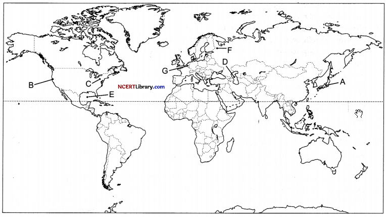
Answer:
A. Tokyo
B. Silicon valley
C. Pittsburgh
D. Caspian Sea
E. Gulf of Mexico
F. St. Petersburg
G. Brussels
Question 30.
On the given political map of India, locate and label any five of the following with appropriate symbols: [5]
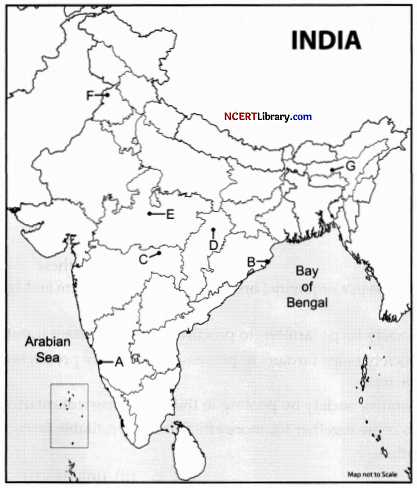
A. Iron mine in Karnataka.
B. Important iron ore exporting port in Odisha.
C. Important manganese field in Maharasthra.
D. Important coal mine in Chhattishgarh.
E. Identify oil refinery in Madhya Pradesh.
F. Identify the religious and cultural town in Punjab.
G. Important administrative town in Assam.
Answer:
A. Ratnagiri
B. Paradwip
C. Nagpur
D. Korba
E. Bina
F. Amritsar
G. Guwahati