Practicing the CBSE Sample Papers for Class 12 Geography with Solutions Set 4 allows you to get rid of exam fear and be confident to appear for the exam.
CBSE Sample Papers for Class 12 Geography Set 4 with Solutions
Time : 3 Hours
Max. Marks : 70
General Instructions:
- Question paper is divided into 4 sections A, B, C & D
- In section A question number 1 to 17 are MCQ-type questions.
- In section B question number 18-23 are SA-type questions (80-100 words). Question 18 & 19 are Source based questions.
- In section C question number 24 to 28 are Long Answer based questions (120-150 words).
- In section D question number 29 & 30 are Map based questions having 5 sub parts.
Section – A (17 Marks)
Question 1.
Why is the dichotomy between physical and human not a valid one? [1]
(a) Nature and humans are inseparable elements.
(b) The biosphere has elements of the other three domains.
(c) Humans explore and create new resources.
(d) Humans are destroying the environment in the name of development.
Answer:
(a) Nature and humans are inseparable elements.
Question 2.
Which authority in case of the major ports decides the policy and plays regulatory functions? [1]
(a) Port Authority
(b) Local Authority
(c) State Authority
(d) Central Authority
Answer:
(d) Central Authority
Question 3.
Identify the Push and Pull factors respectively. [1]
(a) Better job opportunities and Stability
(b) Natural disasters and Pleasant climate
(c) Unpleasant climate and Better living conditions
(d) Unemployment and Epidemics
Answer:
(b) Natural disasters and Pleasant climate
![]()
Question 4.
In human development, empowerment means to have the power to _________. [1]
(a) make choices
(b) purchase goods
(c) exercise one’s veto power
(d) obtain welfare benefits
Answer:
(a) make choices
Question 5.
Arrange the sequence of the steps involved in shaft mining. [1]
(i) The minerals then go through different stages of processing and refining.
(ii) Minerals are extracted and transported to the surface through these passages using specially designed lifts.
(iii)When the ore lies deep below the surface, underground mining/shaft method is used.
(iv)Vertical shafts have to be sunk, from where underground galleries radiate to reach the minerals.
Choose the correct option:
(a) (iii), (iv),(i),(ii)
(b) (iii), (iv), (ii), (i)
(c) (ii), (iii), (iv), (i)
(d) (iii), (ii), (iv), (i)
Answer:
(b) (iii), (iv), (ii), (i)
Question 6.
Medical tourism brings abundant benefits to developing countries like _________. [1]
(a) India, Bangladesh, Myanmar
(b) China, Sri Lanka and Singapore
(c) Pakistan, Indonesia and India
(d) India, Thailand, Singapore and Malaysia
Answer:
(d) India, Thailand, Singapore and Malaysia
Question 7.
Considered the following statements and choose the correct answer from the given options: [1]
1. Human beings have evolved different methods of communication over times.
2. Initially, the means of communication were also the means of transportation.
Options:
(a) Only 1 is correct.
(b) Only 2 is correct.
(c) Both the statements are incorrect.
(d) Both the statements are correct and statement 2 is the correct explanation of statement 1.
Answer:
(d) Both the statements are correct and statement 2 is the correct explanation of statement 1.
Question 8.
Which one of the following is the main factor of the emergence of ports as gateways of international trade? [1]
(a) After the coming of the European traders.
(b) Since ancient times.
(c) After independence.
(d) After the coming of the Mughals.
Answer:
(a) After the coming of the European traders.
Question 9.
The total utilisable water resource of India is: [1]
(a) 1122 cubic km
(b) 1222 cubic km
(c) 1322 cubic km
(d) 1422 cubic km
Answer:
(a) 1122 cubic km
Question 10.
Identify the correctly matched pair: [1]
| List of Minerals | Mining Area |
| (a) Iron core | Balaghat (M.P) |
| (b) Mica | Katni (M.P) |
| (c) Copper | Mayurbhaj (Odisha) |
| (d) Bauxite | Nellore (Andhra Pradesh) |
Answer:
| (c) Copper | Mayurbhaj (Odisha) |
Question 11.
Towns are classified based on evolution as: [1]
(a) Ancient towns
(b) Modem towns
(c) Medieval towns
(d) All of the above
Answer:
(d) All of the above
Question 12.
Identify the incorrectly matched pair: [1]
| Year of Establishment | |
| (a) Atomic Energy Commission | 1948 |
| (b) Atomic Energy Institute at Trombay | 1954 |
| (c) Bhabha Atomic Research Center | 1967 |
| (d) Oil and Natural Gas commission | 1958 |
Answer:
| (d) Oil and Natural Gas commission | 1958 |
Question 13.
Assertion (A): Human geography attempts to explain the relationship between all elements of human life and the space they occur over.
Reason (R): The process of adaptation, adjustment with and modification of the environment started with the appearance of human beings over the surface of the earth in different ecological niches. [1]
(a) Both assertion and reason are true and reason is the correct explanation of assertion.
(b) Both assertion and reason are true but reason is not the correct explanation of assertion.
(c) Assertion is true but reason is false.
(d) Assertion is false but reason is true.
Answer:
(b) Both assertion and reason are true but reason is not the correct explanation of assertion.
![]()
Question 14.
Assertion (A) : Environmental pollution results from the lease of substances and energy from waste products of human activities.
Reason (R) : There are many types of pollution. [1]
(a) Both assertion and reason are true and reason is the correct explanation of assertion.
(b) Both assertion and reason are true but reason is not the correct explanation of assertion.
(c) Assertion is true but reason is false.
(d) Assertion is false but reason is tme.
Answer:
(b) Both assertion and reason are true but reason is not the correct explanation of assertion.
Read the passage carefully and answer any three of the following questions:
Population growth in different parts of the world can be compared. The growth of population is low in developed countries as compared to developing countries. There is negative correlation between economic development and population growth. Although the annual rate of population change (1.4 percent) seems to be low (Source: Demographic Year Book, 2015), it is actually not so.
This is because:
(i) When a small annual rate is applied to a very large population, it will lead to a large population change.
(ii) Even if the growth rate continues to decline, the total population grows each year. The infant mortality rate may have increased as has the death rate during childbirth.
Question 15.
What type of correlation exists between economic development and population growth? [1]
(a) Negative correlation
(b) Positive correlation
(c) Fluctuating correlation
(d) No correlation
Answer:
(a) Negative correlation
Question 16.
What will happen when a small annual rate is applied to a very large population? [1]
(a) It will lead to a small population change.
(b) It will lead to a negligible population change.
(c) It will lead to a large population change.
(d) It will lead to a very small population change.
Answer:
(c) It will lead to a large population change.
Question 17.
What will happen to the population even when the growth rate continues to decline? [1]
(a) A part of the population grows each year.
(b) The total population grows each year.
(c) A part of the population does not grow.
(d) The total population is affected by disease and death.
Answer:
(b) The total population grows each year.
Section – B (18 Marks)
Question 18.
Read the passage carefully and answer the following questions: [3]
“Formal expression of religions on landscape is manifested through sacred structures, use of cemeteries and assemblages of plants and animals, groves of trees for religious purposes. Sacred structures are widely distributed throughout the country. These may range from inconspicuous village shrines to large Hindu temples, monumental masjids or ornately designed cathedrals in large metropolitan cities. These temples, masjids, gurudwaras, monasteries and churches differ in size, form, space-use and density, while attributing a special dimension to the total landscape of the area.”
(i) Name the most commonly followed religion in India.
Answer:
Hinduism- with 79.8% of the Indian population.
(ii) Name the major religions followed in India.
Answer:
The major religions are – Hinduism, Islam, Sikhism, Christianity, Buddhism, Jainism, Zoroastrianism, Judaism and Teh Bahai.
(iii) State the significance of religious landscape.
Answer:
Religious landscape manifest the formal expression of religion through sacred structures, use of cemeteries and assemblages of plants and animals, groves of trees for religious purposes.
Question 19.
Study the picture given below and answer the following questions: [3]
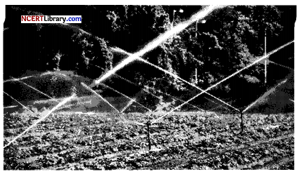
(i) Identify the type of irrigation shown in the diagram.
Answer:
Sprinkler irrigation.
(ii) Define the process.
Answer:
Sprinkler irrigation is a method of providing rainfall-like irrigation to the crops. Water is distributed through a system of pipes usually by pumping. Spray heads at the outlets distribute the water over the entire soil surface and help to conserve water.
(iii) Define irrigation and also mention its main sources.
Answer:
The artificial method of watering the plants for assisting in their growth is called irrigation. Main sources of irrigation are wells, tube-wells, ponds, lakes, rivers.
Question 20.
“Physical environment has been greatly modified by human beings, it has also, in turn impacted human lives.” Explain the statement.
OR
“The period from 1951 to 1981 is referred to as a phase of population explosion in India.” Substantiate the statement. [3]
Answer:
Human geography deals with the inter-relationship between the physical environment and socio-cultural environment created by human beings through mutual interactions with each other. “The physical environment like landforms, soils, climate, water, natural vegetation and diverse flora and fauna has been greatly modified by human beings, which in turn, has also impacted human lives”.
This statement absolutely makes sense because houses, villages, cities, road-rail networks, industries, farms, ports, things of our daily use and all other elements of material culture have been created by human beings using the resources provided by the physical environment.
OR
The decades 1951-1981 are referred to as the period of population explosion in India, which took place due to rapid fall in the mortality rate but a high fertility rate of population in the country. During this period, the population of India grew from 361 million in 1951 to 683 million in 1981. There was a growth in population by 322 million during this phase.
This was the phase when both death rate, as well as birth rate, declined. The average annual growth rate was as high as 2.2 percent. It is in this period, after the Independence, that development activity was introduced through a centralized planning process and the economy started showing up ensuring the improvement of the living condition of people at large.
![]()
Question 21.
Write three points on how can international trade be detrimental for countries.
OR
Assess the role of natural phenomenons in determining the level of international trade of a country. [3]
Answer:
International trade can prove to be detrimental to nations:
1. It leads to dependence of less developed countries on other more developed countries.
2. Resources are used faster than the rate of replenishment because composition to trade more, i.e., production increases.
3. Global trade also results in uneven development level in countries. Critics believe it creates situation where rich countries go richer and poor countries go poorer.
OR
Natural phenomenons like geological structure and mineral reserves play a vital role:
Geological structure: It determines the mineral resource base and topographical differences ensure diversity of crops and animals raised. Lowlands have greater agricultural potential. Mountains attract tourists and promote tourism.
Mineral resources: They are unevenly distributed over the world. The availability of mineral resources provides the basis for industrial development.
Question 22.
Highlight the key aspects of the ‘Period of Population Explosion in India’. [3]
Answer:
The characteristics features of the ‘Period of Population Explosion in India’ are:
1. Decades 1951-1981 are referred to as the ‘Period of Population Explosion’.
2. Caused due to high natural growth rate, i.e., rapid decline in the mortality rate and high fertility rate of population in the country.
3. The development activities were introduced after independence economic graph showing up which ensure the improvement of living condition of people at large
Question 23.
Evaluate the characteristics of India’s foreign trade. [3]
Answer:
- Over time, the nature of India’s overseas trade has evolved. Despite the fact that the overall volume of imports and exports increased, the value of imports remained larger than the value of exports.
- There has also been an increase in the trade deficit over the last couple of years because of the rise in crude oil prices, a key component of India’s international trade is responsible for the deficit increase.
- The percentage of primary goods in India’s overall export has declined over time, while the share of petroleum products has increased. At the same time, the share of manufactured items has remained constant.
Section – C (25 Marks)
Question 24.
Discuss the world’s basic needs approach to human development. [5]
Answer:
The International Labour Organization (ILO) was the first to suggest a basic needs approach to human development throughout the globe. The subject of human choice is neglected in this approach, as the primary focus is on meeting fundamental requirements. These absolute necessities are prerequisites for a person to sustain and meet their basic needs. In this method, six fundamental demands are included.
The following are their details:
1. Maintaining a healthy weight necessitates good health.
2. Schools and colleges provide education.
3. Nutritious food that meets daily needs.
4. Availability of Water: Drinking water that is safe to drink.
5. To maintain hygiene, a proper sanitation system is required.
6. A decent location to live with basic amenities.
Question 25.
Explain trading services.
OR
Write a short note on services. [5]
Answer:
Trade essentially includes buying and selling of items produced elsewhere for profit.
1. It is conducted at certain places known as trading centres which are rural or urban. Rural marketing centres provide services to rural folk as per their needs, e.g., local mandis or periodic markets in rural areas, haats; urban marketing centres include Big Bazaar, polyclinics, etc.
2. Trading is wholesale or retail.
3. Retail trading: Goods are sold to consumers either in shops, i.e., retail stores or local departmental stores, chain stores (like Big Bazaar) or through non-store retail commerce, telephones, mail order or door-to-door services, street vendors.
4. Wholesale trading: Goods are procured in bulk from the producers or manufacturers on low rates and supplied to retailers. It also provides credit to retailers. Some big chains also procure goods on wholesale rates and sell them to consumers directly.
OR
Services occur at different levels. Some are geared to industry, some to people, and some to both industry and people, e.g., transportation system. Low-order services, such as grocery shops and laundries are more common and widespread than high-order services. High-order services are more specialized ones, like those of accountants, consultants and physicians.
Services are provided to individual consumers who can afford to pay for them. For example, gardeners, launderers and barbers primarily perform physical labour. Teachers, lawyers, physicians, musicians and others perform mental labour.
Question 26.
“International trade has shown detrimental effects on underdeveloped and developing economies”. Do you agree or not? Justify your stand.
OR
Categorize the ports on the basis of the specialised functions performed by them. [5]
Answer:
International trade can prove to be detrimental to nations in the following ways:
1. Underdeveloped and developing nations depend upon developed nations because of their specialization in the production process.
2. International trade makes rich countries richer and leads to uneven global development.
3. The third .world countries commonly become the raw material suppliers to feed the industries of developed nations. For e.g., colonies of European countries.
4. Underdeveloped nations, in order to compete global trade, increase their production activities by extracting the natural resources excessively.
5. Organisations in such countries are focused only towards profit making, and environmental and health concerns are least concerned, which leads to serious implications in the future.
OR
Types of port on the basis of their specialised functions performed by them:
Oil Ports: These ports deal in the processing and shipping of oil. Some of these are tanker ports and some are refinery ports. Maracaibo in Venezuela, Esskhira in Tunisia, and Tripoli in Lebanon are tanker ports. Abadan on the Gulf of Persia is a refinery port.
Ports of Call: These are ports which originally developed as calling points on main sea routes where ships used to anchor for refuelling, watering and obtaining food items. Later, they developed into commercial ports. Aden, Honolulu and Singapore are good examples of such ports.
Packet Stations: These are also known as ferry ports. These packet stations are exclusively concerned with the transportation of passengers and mail across water bodies covering short distances. These stations are located in pairs in such a way that they face each other across the water body, e.g. Dover in England and Calais in France across the English Channel.
Entrepot Ports: These are collection centres where goods are brought from different countries for export. Singapore is an entrepot for Asia, Rotterdam for Europe, and Copenhagen for the Baltic region.
Naval Ports: These are ports which have only strategic importance. These ports serve warships and have repair workshops for them. Kochi and Karwar are examples of such ports in India
Question 27.
Write a short note on the functional classification of towns. [5]
Answer:
Some towns and cities are recognized for specific activities, goods, or services because they specialise in certain spheres.
The following are general classifications for Indian cities and towns:
Administrative towns: Cities such as Chandigarh, New Delhi, Bhopal, Shillong, Guwahati, Imphal, Srinagar, Gandhinagar, Jaipur, Chennai, and others serve as administrative headquarters of higher rank.
Industrial towns: Cities like Mumbai, Salem, Coimbatore, Modinagar, Jamshedpur, Hugli, Bhilai, and others rely heavily on industry.
Transport cities: These may be ports primarily engaged in export and import activities such as Kandla, Kochchi, Kozhikode, Vishakhapatnam, etc. or hubs of inland transport such as Agra, Dhulia, Mughal Sarai, Itarsi, Katni, etc.
Commercial towns: Towns and cities specialising in trade and commerce are included in this category. Kolkata, Saharanpur, Satna, etc. are some major examples.
Mining towns: These towns have developed in mineral-rich areas such as Raniganj, Jharia, Digboi, Ankleshwar, Singrauli, etc.
![]()
Question 28.
“Slums have evolved as one of the biggest causes behind rapid environmental degradation in the urban centres.” Justify. [5]
Answer:
Slums are one of the biggest causes of rapid degradation in the urban environment. It affect the environment of urban centres adversely in the following ways:
Unplanned Development: Unplanned and uncontrolled rise of the infrastructure of slums, often through landfill and ‘concrete jungle’ consequently results into land, air and water pollution.
Loss of Green Cover: Master Plan of any city is developed keeping in mind the natural growth rate of population in the city but the outward expansion of the city due to the rise of slums on the outer edge disturbs the Master Plan as the expansion takes place at the cost of the nearby agricultural land and other forms of green cover, which eventually causes land and air pollution.
Excessive Waste Generation: Slums generate the largest share of the total solid waste in an urban agglomeration. This waste is not disposed properly and left unattended on the ground, which is the biggest cause of land pollution in urban centres.
Depletion in Quality and Quantity of Resources: Extremely high density of population in the slums has resulted into undue and immense pressure on land and water resources.
Overall Critical Levels of Pollution: Rise and existence of slums results in increased congestion, sewage, waste generation, concrete infrastructure and traffic which in turn cause an increase in environmental degradation and pollution, in general.
Section – D (10 Marks)
Question 29.
On the given political map of the world, the following seven features are shown. Identify any five of these features and write their correct names on the lines marked near each feature. [5]
A. The country with the lowest density of population in Asia.
B. Name the country with the smallest population of Asia.
C. A port on Southern end of South Africa.
D. A port on South Pacific Coast in Australia.
E. Important Iron and steel centre in U.K.
F. The region responsible for 80 percent of Germany’s total steel production.
G. Eastern terminal of Trans-Siberian Railway
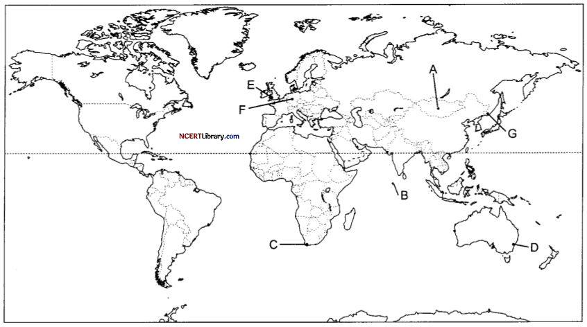
Answer:
A. Mongolia
B. Maldives
C. Cape Town
D. Sydney
Answer:
A. Mongolia
B. Maldives
C. Cape Town
D. Sydney
Question 30.
On the given political map of India, locate and label any five of the following with appropriate symbols: [5]
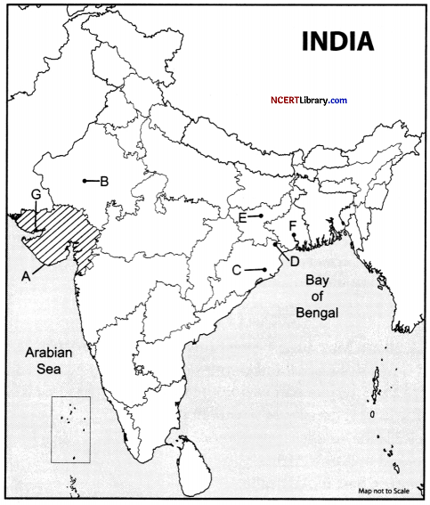
A. Identify the state of India that utilised underground at a moderate rate.
B. Choose the town which has been known as a tourist destination in Rajasthan
C. Identify the town which has been developed as administrative headquarters.
D. Manganese mines of Odisha.
E. Copper mines of Jharkhand.
F. The oldest operational port in India.
G. Identify the port that was built during the India-Pakistan partition.
Answer:
A. Gujarat
B. Jodhpur
C. Bhubaneshwar
D. Mayurbhanj
E. Hazaribagh
F. Kolkata port trust
G. Kandalaport
![]()