Practicing the CBSE Sample Papers for Class 12 Geography with Solutions Set 2 allows you to get rid of exam fear and be confident to appear for the exam.
CBSE Sample Papers for Class 12 Geography Set 2 with Solutions
Time : 3 Hours
Max. Marks: 70
General Instructions:
- Question paper is divided into 4 sections A, B, C & D
- In section A question number 1 to 17 are MCQ-type questions.
- In section B question number 18-23 are SA-type questions (80-100 words). Question 18 & 19 are Source based questions.
- In section C question number 24 to 28 are Long Answer based questions (120-150 words).
- In section D question number 29 & 30 are Map based questions having 5 sub-parts.
Section -A (17 Marks)
Question 1.
Human geography studies the relationship between_______the spatial distributions of human phenomena and how they come about, and the social and economic differences between different parts of the world. [1]
(a) the physical and biological worlds
(b) the resting man and the stable earth
(c) the natural phenomena and earth science
(d) the physical and the human worlds
Answer:
(d) the physical and the human worlds
Question 2.
Which of the following pairs is matched correctly? [1]
| Human anatomy for regions, villages, towns | cell |
| Human anatomy for part of glacier | Snout |
| Term is used to explain different layer of the soil | Limbs |
| Arteries of circulation | Ocean Current |
Answer:
| Human anatomy for part of glacier | Snout |
Question 3.
Change of population in a particular area between two points of time is known as_______. [1]
(a) growth of population
(b) natural growth of population
(c) positive growth of population
(d) negative growth of population
Answer:
(a) growth of population
Question 4.
In human development, sustainability means continuity in the availability of_______. [1]
(a) natural resources
(b) raw materials
(c) capital
(d) opportunities
Answer:
(d) opportunities
Question 5.
Primitive people living in_______survived on hunting. [1]
(a) very cold climate
(b) extremely hot climate
(c) very cold and extremely hot climates
(d) wet and moderate climates
Answer:
(c) very cold and extremely hot climates
![]()
Question 6.
Governments adopt_______to promote ‘balanced’ economic development and hence set up industries in particular areas. [1]
(a) ‘national policies
(b) ‘subsidized policies’
(c) ‘import policies
(d) ‘regional policies
Answer:
(d) ‘regional policies
Question 7.
Which of the following is not matched correctly? [1]
| Ways of Transport | Medium of Transport |
| a. Ropeways | Waterways |
| b. Highways | Landways |
| c. Cableways | Landways |
| d. Pipeline | Landways |
Answer:
| a. Ropeways | Waterways |
Question 8.
Which one of the following commodities of India’s export declined during 2009-17? [1]
(a) Agriculture and allied products
(b) Petroleum and crude products
(c) Ore and Minerals
(d) Manufactured goods
Answer:
(c) Ore and Minerals
Question 9.
Which of the following months of the year are included in Kharif Cropping Season? [1]
(a) June – September
(b) October – March
(c) April – June
(d) July – October
Answer:
(a) June – September
Question 10.
The total utilizable water resource of India is: [1]
(a) 1122 cubic km
(b) 1222 cubic km
(c) 1322 cubic km
(d) 1422 cubic km
Answer:
(a) 1122 cubic km
Question 11.
Arrange the following cities in the sequence of their ranks i.e., 1, 2, 3, 4. [1]
(i) Kolkata
(ii) Delhi
(iii) Greater Mumbai
(iv) Chennai
Options:
(a) (i), (ii), (iii), (iv)
(b) (ii), (iii), (i), (iv)
(c) (iii), (i), (ii), (iv)
(d) (ii), (iv), (iii), (i)
Answer:
(c) (iii), (i), (ii), (iv)
Question 12.
Which of the statements given below is true?
I. Rainwater harvesting increases groundwater recharge by capturing and storing rainwater locally in subsurface water reservoirs to meet household needs.
II. Rainwater harvesting is a technique of decreasing the recharge of tank water by capturing and storing rainwater locally subsurface water reservoirs to meet industrial needs. [1]
(a) Only I is true
(b) Only II is true
(c) Both I and II are true
(d) Both I and II are false
Answer:
(a) Only I is true
Question 13.
Assertion (a): Air transport is the slowest means of movement from one place to the other.
Reason (R): It is essential for a vast country like India, where distances are large and the terrain and climatic conditions are diverse. [1]
(a) Both assertion and reason are true and reason is the correct explanation of assertion.
(b) Both assertion and reason are true but reason is not the correct explanation of assertion.
(c) Assertion is true but reason is false.
(d) Assertion is false but reason is true.
Answer:
(d) Assertion is false but reason is true.
![]()
Question 14.
Assertion (a): Combustion of fossil fuels, mining, and industries are the main sources of air pollution
Reason (R): These processes release oxides of sulfur and nitrogen, hydrocarbons, carbon dioxide, carbon monoxide, lead, and asbestos. [1]
(a) Both assertion and reason are true and reason is the correct explanation of assertion.
(b) Both assertion and reason are true but reason is not the correct explanation of assertion.
(c) Assertion is true but reason is false.
(d) Assertion is false but reason is true.
Answer:
(a) Both assertion and reason are true and reason is the correct explanation of assertion.
Read the following case study and answer questions no 15 to 17.
Benda lives in the wilds of the Abuja Maad area of Central Indi(a) His village consists of three huts deep in the wilds. Not even birds or stray dogs that usually crowd villages can be seen in these areas. Wearing a small loin cloth and armed with his axe he slowly surveys the panda (forest) where his tribe practices a primitive form of agriculture called shifting cultivation.
Benda and his friends bum small patches of forest to clear them for cultivation. The ash is used for making the soil fertile. Benda is happy that the Mahua trees around him are in bloom. How lucky I am to be a part of this beautiful universe, he thinks as he looks up to see the Mahua, Palash, and Sal trees that have sheltered him since childhood (d) Crossing the panda in a gliding motion, Benda makes his way to a stream.
As he bends down to scoop up a palmful of water, he remembers to thank Loi-Luigi, the spirit of the forest for allowing him to quench his thirst. Moving on with his friends, Benda chews on succulent leaves and roots. The boys collect Gajjhara and Kuchla, from the forest. These are special plants that Benda and his people use. He hopes the spirits of the forest will be kind and lead him to these herbs. These are needed to barter in the madhab or tribal fair coming up the next full moon.
Question 15.
In what type of settlement does Benda live? [1]
(a) A rural settlement near the forest.
(b) A forested village in the midst of a small town.
(c) A large primitive village in a forest consisting of several huts.
(d) A small primitive village in the wild consisting of a few huts.
Answer:
(d) A small primitive village in the wild consisting of a few huts.
Question 16.
Which type of primitive agriculture does the tribe practice? [1]
(a) Subsistence agriculture
(b) Shifting cultivation
(c) Intensive agriculture
(d) Crop rotation
Answer:
(b) Shifting cultivation
Question 17.
Why did Benda thank Loi-Luigi, after drinking water from the stream? [1]
(a) Because he was extremely thirsty.
(b) Because he forgot to carry water along with him.
(c) Because his tribe worships ‘Mother Nature’ which provides everything for their survival.
(d) Because if he did not thank Loi-Luigi, the forest spirit would get angry.
Answer:
(c) Because his tribe worships ‘Mother Nature’ which provides everything for their survival.
Section – B (18 Marks)
Question 18.
Read the passage carefully and answer the following questions: [3]
Patterns of population distribution and density help us to understand the demographic characteristics of any area (a) The term population distribution refers to the way people are spaced over the earth’s surface. Broadly, 90 percent of the world’s population lives in about 10 percent of its land area. The 10 most populous countries of the world contribute about 60 percent of the world’s population. Of these 10 countries, 6 are located in Asia.
(i) What helps us to understand the demographic characteristics of any area?
Answer:
Patterns of population distribution and density help us to understand the demographic characteristics of any area.
(ii) Explain the term population distribution.
Answer:
The term population distribution refers to the way people are spaced over the earth’s surface.
(iii) What percentage do the 10 most populous countries of the world contribute?
Answer:
The 10 most populous countries of the world contribute about 60 percent of the world’s population.
![]()
Question 19.
Study the map given below carefully and answer the questions that follow: [3]
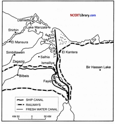
(i) Identify and name the canal shown on the map.
Answer:
The canal shown in the map is Suez Canal, constructed in 1869 between Port Said and Port Suez in Egypt.
(ii) This canal connects which two seas?
Answer:
Suez canal linking the Mediterranean sea and the red sea.
(iii) Write any two characteristics of this canal.
Answer:
The main characteristics of this canal are :
1. It provides Europe a new gateway to the Indian Ocean and reduces the sea-route distance between Liverpool and Colombo by 6400 km compared to the Cape of Good Hope route.
2. About 100 ships travel daily and each ship takes around 10-12 hours to cross the canal.
Question 20.
How do socio-economic factors affect the population distribution in India?
OR
Highlight the key aspects of the ‘Period of Population Explosion in India’. [3]
Answer:
The effects of socio-economic factors on population distribution in India are:
1. Concentrations of the population around regions of economic development especially in fields like agriculture, industries, transportation, etc.
2. Social factors such as better housing, education, and healthcare facilities often attract more population.
3. For example Development of irrigation in Rajasthan, availability of mineral and power resources in Jharkhand, and better transportation facilities in Peninsular India have resulted in a moderate to high concentration of population in those areas, which were very thickly populated earlier.
OR
The characteristic features of the Period of Population Explosion in India are:
1. Decades of 1951-1981 are referred to as the ‘Period of Population Explosion.
2. It took place due to a high natural growth rate, i.e., rapid decline in the mortality rate and high fertility rate of the population in the country.
3. The developmental plans were introduced after independence, shooting up the economic graph, which exhibits improvement in living conditions of people at large.
Question 21.
What are the main functions of the National Highway Authority of India (NHAI)? [3]
Answer:
The National Highway Authority of India was constituted by an act of Parliament in 1988 and set up in 1995.
1. It works as an autonomous body under the Ministry of Road Transport and Highway.
2. It is entrusted with the responsibility of development, maintenance, and operation of National Highways.
3. It is the apex body responsible for maintaining and improving the quality of the National Highways.
Question 22.
Mention the types of changes that an economy undergoes, which affect the land use of the region.
OR
Why has the Green Revolution strategy in India been more successful in northern India? [3]
Answer:
Following are the type of changes that an economy undergoes that affect land use:
1. The size of the economy.
2. The composition of the economy.
3. The contribution of agricultural activities.
OR
In Punjab, Haryana, and western Uttar Pradesh, more than 85 percent of the net sown area is under irrigation. The high-yielding varieties of crops need a regular moisture supply, which is made possible only by developed irrigation systems. Hence, the green revolution strategy of agriculture development has been more successful in Punjab, Haryana, and western Uttar Pradesh.
![]()
Question 23.
Distinguish between Population Density, Physiological Density, and Agricultural Density. [3]
Answer:
Population Density is expressed as the number of persons per unit area.
Population Density = Total Population in a Region
Area of Respective Region (in sq. km.)
Physiological Density is the number of persons in a region per net cultivated area.
Physiological Density = Total Population
Net Cultivated Area (in sq. km.)
Agricultural Density is the number of the total agricultural population including cultivators, agricultural laborers and their families per net cultivated area.
Agricultural Density = Total Agricultural Population
Net Cultivated Area (in sq. km.)
Section – C (25 Marks)
Question 24.
“90 percent of the world population lives in about10 percent of its total land area, whereas the remaining 10 percent of the population resides in the 90 percent of its land area”. Support the statement with suitable examples. [5]
Answer:
An example that supports the statement is given below:
1. Cultural Factors: Traditions and culture of a place include the distribution of a population. People like to migrate to areas where common traditions and cultures are found.
2. Physical Factors: Relief, climate, soil, and mineral are the physical factors that determine the population of any place. Tibet is a region with a very less population, whereas the Indo-Gangetic plain is overpopulated.
3. Means of Transport: Regions with better facilities means transport leads to better economic conditions. This led to a thick population. The Mumbai-Pune Industrial region is the best example.
4. Economic Condition: Industrial and agricultural regions of the world are thickly populated. The industrial region of India, the USA, Japan, and UK are the examples.
Question 25.
Discuss in detail three prime about Trans-Continental Railways.
OR
Discuss the importance of Inland Waterways. [5]
Answer:
Trans-continental railways run across the continent and link its two ends. The following are the most important of these:
1. Trans-Siberian Railways: This is a major rail route of Russia that runs from St. Petersburg in the west to Vladivostok on the Pacific Coast in the east passing through Moscow, Ufa, Novosibirsk, Irkutsk, Chita, and Khabarovsk. It is the most important route in Asia and also the longest (9,332 km) double-tracked and electrified trans-continental railway in the world.
2. Trans-Canadian Railways: This 7,050 km long rail line in Canada runs from Halifax in the east to Vancouver on the Pacific Coast passing through Montreal, Ottawa, Winnipeg, and Calgary. It was constructed in 1886, it connected the Quebec-Montreal Industrial Region with the wheat belt of the Prairie Region and the Coniferous Forest Region in the north.
3. The Union and Pacific Railways: This rail line connects New York on the Atlantic Coast San Francisco on the Pacific Coast passing through Cleveland, Chicago, Omaha, Evans, Ogden, and Sacramento. The most valuable exports on this route are ores, grain, paper, chemicals, and machinery.
OR
1. Rivers, canals, lakes, and coastal areas have been important waterways since time immemorial. Boats and steamers are used as means of transport for cargo and passengers.
2. Rivers are the only means of transport in dense forests. Very heavy cargo like coal, cement, timber, and metallic ores can be transported through inland waterways.
3. The Maintenance cost of inland waterways is also very less as compared to roadways and railways.
4. This mode of internal transportation has way less risk than roadways, railways, and airways with the highest fuel efficiency.
![]()
Question 26.
Make a list of the elements that influence the location of a rural village. [5]
Answer:
The following variables have an impact on the location of rural settlements:
1. Water supply: For easy access, rural villages are frequently placed near water sources such as rivers and lakes. Because water is necessary for living, humans are forced to reside in marshes or floodplains. People use water sources to drink, cook, and wash their clothes, as well as to irrigate farms, engage in fishing, and travel.
2. Land: For rice production, people dwell near rich lands such as Rolling Meadows in Europe and low-lying places, river valleys, and coastal plains in Southeast Asia.
3. Upland: Another element that determines the placement of rural villages is higher terrain that is not prone to flooding.
4. People tend to avoid low-lying river basins and instead choose DIY sites like terraces and levees. People in tropical nations construct their houses on stilts to prevent flooding, mosquitoes, and animal infestations.
5. Another advantage is the proximity of building resources such as wood and stone to the community. Villages were first built in woodland clearings, where timber was plentiful.
6. Villages were built on defensible hills and islands to avoid political instability and enmity from surrounding communities. For example, forts in India are constructed on high ground.
Question 27.
Describe any five health effects of air pollution. [5]
Answer:
The following are the health effects of air pollution:
1. Respiratory Diseases: There is a significant rise in the cases of respiratory diseases such as asthma, whooping cough, pneumonia, chronic obstructive pulmonary diseases, and other lung diseases.
2. Cardio-Vascular Diseases: Stroke and heart diseases like high blood pressure, heart attacks, etc are one of the main health consequences of air pollution, and have a high rate of fatality due to inhaling harmful, toxic pollutants in the air.
3. Decreasing Immunity: The toxic gases cause harm to the white blood cells in the body, depleting the natural immunity of the body. Air pollution is also a cause of blood cancer and other blood-related diseases.
4. Neurological Diseases: Severe headaches, migraines, loss of neural cells, declined cognition and dementia are pollution-induced nervous system dysfunction continuous exposure to particulate matter reduces white and grey matter in the brain resulting in such neurological diseases.
5. Psychological Diseases: Stress-induced depression, anxiety, autism, Parkinson’s, Alzheimer’s, and mood and behavioral changes are only a few psychological consequences of air pollution.
Question 28.
“There is the low yield per acre but high yield per person.” Which type of agriculture is being talked about here? Give a detailed brief about this type of agriculture.
OR
Classify industries on different the basis of size. [5]
Answer:
Commercial grain cultivation is the type of agriculture is being talked about here. The main features of this type of agriculture are:
1. The size of the farm is very large.
2. All operations of cultivation from plowing to harvesting are mechanized.
3. There is low yield per acre but a high yield per person.
4. In the areas practicing commercial grain cultivation, the areas of production are high, as the farming is intensive, but due to low population and a high degree of mechanization, the number of people employed in these farms is less.
5. Due to the high level of scientific and technological skills employed in the production activities, the overall yield is high.
6. Commercial grain cultivation is practiced in the interior parts of semi-arid lands of the multitudes.
7. Wheat is the principal crop. However, other crops like com, barley, oats, and rye are also grown.
8. This type of agriculture is largely practiced in Eurasian Steppes, the Canadian and American Prairies, the Pampas of Argentina, the Velds of South Africa, the Australian Downs, and the Canterbury Plains of New Zealand.
OR
Classification based on Size: The amount of capital invested, number of people employed and the volume of production determines the size of an industry. Accordingly, industries may be classified into the following groups :
1. Cottage or household: These are smallest manufacturing units. The craftsmen the artisans with the help of their part-time labor i.e., family members, manufacture goods within their homes. These use local raw material and simple tools. The skills of production are passed on from one generation to the other. The scale of operation is small. The tools and equipment are ordinary. The goods produced are generally sold locally. For example potters, carpenters, weavers and blacksmiths produce goods in the household sector.
2. Small scale: They use modem power driven machines and employ semi-skilled labour as well. The raw materials are also obtained from outside, if not available locally. These industries are larger in size than cottage industries. Their products are sold through traders beyond local markets. They provide employment to a large number of people.
Example : A large number of goods such as clothes, toys, furniture, edible oil and leather goods are produced by small scale industries.
3. Large-scale industries: These include mainly heavy and capital-intensive industries. These use energy, heavy machinery, employ large numbers of workers and produce goods for a bigger market. Emphasis is laid on quality control and production specialization. Such industries require a very large resource base and hence raw materials are obtained from various places. The production of goods is also on a large scale, which is sent to distant markets.
Example: the Iron and steel industry, petrochemicals, textiles and automobiles.
Section – D (10 Marks)
Question 29.
On the given political map of the world, the following seven features are shown. Identify any five of these features and write their correct names on the lines marked near each feature. [5]
A. An industrial port of South Asia
B. An important country of commercial livestock rearing.
C. An commercial port on Red Sea
D. A port on pacific coast of Canada
E. A major area of commercial livestock rearing.
F. A port of call in Yemen
G. A port on South Atlantic Coast of Brazil
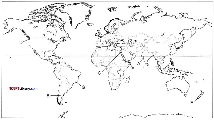
Answer:
A. Mumbai
B. Argentina
C. Suez
D. Vancouver
E. New Zealand
F. Aden
G. Rio De Janeiro
![]()
Question 30.
On the given political map of India, locate and label any five of the following with appropriate symbols: [5]
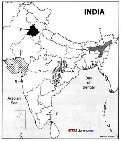
A. Identify the state where hamleted settlements are found in India.
B. Identify the largest agglomeration city in India?
C. The state, is the leading producer of tea in northeastern India.
D. Identify the state of western India that grows sugarcane.
E. Identify the state of India that has the highest utilization of groundwater.
F. Coal mines of Tamil Nadu.
G. Bauxite mines of Madhya Pradesh.
Answer:
A. Chhattisgarh
B. Greater Mumbai
C. Assam
D. Gujarat
E. Punjab
F. Neyveli
G. Katni