Practicing the CBSE Sample Papers for Class 12 Geography with Solutions Set 1 allows you to get rid of exam fear and be confident to appear for the exam.
CBSE Sample Papers for Class 12 Geography Set 1 with Solutions
Time : 3 Hours
Max. Marks: 70
General Instructions:
- Question paper is divided into 4 sections A, B, C & D
- In section A question number 1 to 17 are MCQ-type questions.
- In section B question number 18-23 are SA-type questions (80-100 words). Question 18 & 19 are Source based questions.
- In section C question number 24 to 28 are Long Answer based questions (120-150 words).
- In section D question number 29 & 30 are Map based questions having 5 sub-parts.
Section – A (17 Marks)
Question 1.
Which two cities are connected by Channel Tunnel? [1]
(a) London with Barcelona
(b) London with Berlin
(c) London with Paris
(d) London with Rome
Answer:
(c) London with Paris
Explanation: London with Paris. It is the longest underground tunnel in the world. It is operated by Euro Tunnel Group.
Question 2.
Which of the following pairs is matched correctly? [1]
| NAME OF THE COUNTRY | OIL PORT |
| (a) Tunisia | Tripoli |
| (b) Lebanon | Esskhira |
| (c) Venezuela | Maracaibo |
| (d) Oman | Aden |
Answer:
(c) Venezuela Maracaibo
Explanation: Oil Port lies in Venezuela The Venezuelan State Oil Company runs the oil port of Puerto Maracaibo Miranda
Question 3.
Which of the following may be interpreted as a spontaneous effort to achieve a better balance between population and resources? [1]
(a) Migration
(b) Growth Rate
(c) Birth Rate
(d) Death Rate
Answer:
(a) Migration
Explanation: Migration is a spontaneous effort to achieve a better balance between population and resources.
![]()
Question 4.
Which of the following features is related to the second stage of Demographic Transition Theory? [1]
(a) Fertility and Mortality decline considerably
(b) Decline in Mortality but fertility remains high
(c) Fertility and Mortality are high
(d) Fertility declines and Mortality high
Answer:
(b) Decline in Mortality but Fertility remains high
Explanation: Decline in Mortality but Fertility remains high is the main feature that is related to the second stage of Demographic Transition Theory.
Question 5.
What is the major export from New Mangalore ports? [1]
(a) Coal
(b) Iron ore
(c) Copper
(d) Mica
Answer:
(b) Iron ore
Explanation: Iron ore is the major export from New Mangalore ports.
Question 6.
Which of the following is a feature of Kandla Port? [1]
(a) It is the biggest port of the country
(b) Its harbour is situated at Zuari estuary
(c) It is situated at the head of Gulf of Kachchh
(d) It is the oldest port of India
Answer:
(c) It is situated at the head of Gulf of Kachchh
Explanation:It is situated at the head of Gulf of Kachchh is a feature of Kandla Port.
Question 7.
Which of the following is incorrectly matched? [1]
| NAME OF THE STATE | COAL MINING CENTRE |
| (a) Telangana | Singareni |
| (b) Maharashtra | Korba |
| (c) Odisha | Talcher |
| (d) West Bengal | Raniganj |
Answer:
(b) Maharashtra Korba
Explanation: Maharashtra in Chhattisgarh. (Name of the State)- Korba (Coal Mining Centre) is incorrectly matched Korba is situated in Chhattisgarh.
Question 8.
Identify the correct order of location from west to east, for the given natural gas reserves of India. [1]
(a) Ankleshwar, Tripura, Jaisalmer, Krishna Godavari basin
(b) Jaisalmer, Ankleshwar, Krishna Godavari basin, Tripura
(c) Tripura, Jaisalmer, Krishna Godavari basin, Ankleshwar
(d) Krishna Godavari basin, Ankleshwar, Tripura, Jaisalmer
Answer:
(b) Jaisalmer, Ankleshwar, Krishna Godavari basin, Tripura
Explanation: Jaisalmer, Ankleshwar, Krishna Godavari basin, Tripura – is the correct order of location from west to east, for the given natural gas reserves of India.
Question 9.
Which of the following are industrial towns of India? [1]
(a) Hugli, Salem, Bhilai
(b) Jamshedpur, Pushkar, Ujjain
(c) Coimbatore, New Delhi, Imphal
(d) Chandigarh, Mugalsarai, Shillong
Answer:
(a) Hugli, Salem, Bhilai
Explanation: Hugli, Salem, Bhilai are industrial towns of India.
Question 10.
Which of the following are the features of Urban Settlements in India? [1]
(a) Complex way of life, manufacturing of finished goods, nodes of economic growth.
(b) Intimate social relations, mainly primary economic activities, people are less mobile.
(c) Economy mainly based on primary activities, providing food and raw materials, and social relations are formal.
(d) Provide a variety of services, poor transport networks, social relations are intimate.
Answer:
(a) Complex way of life, manufacturing of finished goods, nodes of economic growth
Explanation: Complex way of life, manufacturing of finished goods, nodes of economic growth – are the features of Urban Settlements in India.
Question 11.
Arrange the following in correct sequence: [1]
Following is the sequence of generating geothermal:
(i) It is so hot that when it rises to the earth’s surface, it turns into steam.
(ii) Groundwater in such areas (where the geothermal gradient is high) absorbs heat from the rocks and becomes hot.
(iii) This steam is used to drive turbines and generate electricity.
(iv) Geothermal energy exists, because the earth grows progressively hotter with increasing depth.
(a) (iv) – (ii) – (i) – (iii)
(b) (ii) – (i) – (iv) – (iii)
(c) (i) – (iv) – (iii) – (ii)
(d) (iii) – (ii) – (iv) – (i)
Answer:
(a) (iv) – (ii) – (i) – (iii)
Question 12.
Consider the following statements and choose the correct option from the given options: [1]
I. The WTO however has been criticized and opposed by those who are worried about the effects of Free trade and economic globalization.
II. Free trade does not make ordinary people’s lives more prosperous.
Options:
(a) Only statement I is correct.
(b) Both the statements are true and statement II correctly present the reason for statement I.
(c) Only Statement II is correct.
(d) Both the statements I and II are incorrect.
Answer:
(b) Both the statements are true and statement II correctly presents the reason for statement I.
Explanation: Because wealthy nations get even wealthier, the gap between the rich and the poor is actually getting wider. This is because the WTO’s powerful member countries concentrate on their own business interests. In addition, several wealthy nations are entirely receptive to merchandise from developing nations. Another argument is that health, workers’ rights, and child labour issues are not taken into account.
Question 13.
Assertion: Settlements can be of various types.
Reason: Various physical factors affect the growth of settlements. [1]
Options:
(a) Only assertion is correct.
(b) Only reason is correct.
(c) Both statements are correct. statement II correctly explains statement I.
(d) Both are correct but not related to each other.
Answer:
(c) Both statements are correct. statement II correctly explains statement I.
Explanation: Settlements vary in size and type. They range from a hamlet to metropolitan People require access to land that can produce food and water, to areas that are conveniently located for those who live there, and to natural resources so they can build their houses and other infrastructure.
![]()
Question 14.
Assertion: Mediterranean regions have been inhabited from early periods in history.
Reason: Plain areas are favourable for the production of crops and to build roads and industries. [1]
(a) Only assertion is correct.
(b) Only reason is correct.
(c) Both assertion and reason are correct and reason is the correct explanation for assertion.
(d) Both assertion and reason are correct but reason is not the correct explanation for assertion.
Answer:
(d) Both assertion and reason are correct but reason is not the correct explanation for assertion.
Explanation: Due to pleasant environment, Mediterranean regions have been inhabited since ancient times. More individuals are drawn to places with pleasant climates and little seasonal change. Reason given here is not the correct explanation. Plain areas are favourable for the production of crops and to build roads and industries.
Read the following case study and answer question no. 15 to 17.
Ralegan Siddhi is a small village in the district of Ahmadnagar, Maharashtra.It has become an example for watershed development throughout the country. In 1975, this village was caught in a web of poverty and illicit liquor trade. The transformation took place when a retired army personnel settled down in the village and took up the task of watershed development. He convinced villagers about the importance of family planning and voluntary labour; preventing open grazing, felling trees, and liquor prohibition.
Voluntary labour was necessary to ensure minimum dependence on the government for financial aid. Even those who were working outside the village contributed to the development by committing a month’s salary every year. Work began with the percolation tank constructed in the village. In 1975, the tank could not hold water. The embankment wall leaked. People voluntarily repaired the embankment.
The seven wells below it swelled with water in summer for the first time in the living memory of the people. The people reposed their faith in him and his visions. A youth group called Tarun Mandal was formed. The group worked to ban the dowry system, caste discrimination and untouchability. Liquor distilling units were removed and prohibition imposed. Open grazing was completely banned with a new emphasis on stall feeding.
The cultivation of water-intensive crops like sugarcane was banned. Crops such as pulses, oilseeds and certain cash crops with low water requirements were encouraged. All elections to local bodies began to be held on the basis of consensus. “It made the community leaders complete representatives of the people.” A system of Nyay Panchayats (informal courts) were also set up.
Since then, no case has been referred to the police. A ₹22 lakh school building was constructed using only the resources of the village. No donations were taken. Money, if needed, was borrowed and paid back. The villagers took pride in this self-reliance. A new system of sharing labour grew out of this infusion of pride and voluntary spirit. People volunteered to help each other in agricultural operations. Landless labourers also gained employment.
Question 15.
Which of the following methods of water conservation brought prosperity in Ralegan Siddhi? [1]
(a) Rainwater harvesting
(b) Watershed development
(c) Groundwater recharge
(d) Construction of dams
Answer:
(b) Watershed development
Explanation: A small village in Maharashtra’s Ahmadnagar district called Ralegan Siddhi serves as a national model for watershed development. This town was entangled in a web of debauchery and illegal alcohol commerce in 1975. When a former army soldier moved there and started working on the watershed development, the community underwent a shift.
Question 16.
Which of the following measures were taken to increase democratic participation in the village? [1]
(a) Construction of school
(b) Local body elections
(c) Liquor prohibition
(d) All of the above
Answer:
(b) Local body elections
Explanation: Consensus-based voting became the norm for all local body elections. The community leaders became full-fledged representatives of the people as a result. Additionally, a system of Nyay Panchayats (informal courts) was established.
Question 17.
Which of the following made Ralegan Siddhi independent of government’s financial aid? [1]
(a) Prohibition of liquor
(b) Voluntary labour
(c) Local body election
(d) Agriculture
Answer:
(b) Voluntary labour
Explanation: The need for voluntary labour was made clear to the villagers by retired army personnel in order to ensure that their reliance on government assistance was kept to a minimum. Even individuals who had jobs outside the hamlet made a yearly donation of one month’s wage toward the development.
Section – B (18 Marks)
Question 18.
Read the given Passage carefully and answer the questions that follow: [3]
Bharmaur tribal area comprises Bharmaur and Holi tehsils of Chamba district of Himachal Pradesh.It has been a notified tribal area since 21 November 1975. Bharmauris inhabited by ‘Gaddi’, a tribal community who have maintained a distinct identity in the Himalayan region as they practiced transhumance and conversed through Gaddiali dialect. Bharmaur tribal region has harsh climate conditions, low resource base and fragile environment.
These factors have influenced the society and Economy of the region. According to the 2011 census, the total population of Bharmaur sub-division was 39,113 i.e., 21 persons per sq. km. It is one of the most (economically and socially) backward areas of Himachal Pradesh. Historically, the Gaddis have experienced geographical and political isolation and socio-economic deprivation. The economy is largely based on agriculture and allied activities such as sheep and goat rearing.
The process of development of the tribal area of Bharmaur started in the 1970s when Gaddis were included among ‘scheduled ‘tribes. Under the Fifth Five-Year Plan, the tribal sub-plan was introduced in 1974 and Bharmaur was designated as one of the five Integrated Tribal Development Projects (ITDP) in Himachal Pradesh.
This area development plan was aimed at improving the quality of life of the Gaddis and narrowing the gap in the level of development between Bharmaur and other areas of Himachal Pradesh. This plan laid the highest priority on development of transport and communications, agriculture and allied activities, and social and community services.
(1) How have the Gaddi Tribal Community maintained a distinct identity in the Himalayan region?
Answer:
Gaddi tribal communities have maintained a distinct identity in the Himalayan region as they practiced transhumance and conversed through Gaddiali dialect.
(2) Which factors have influenced the society and Economy of the region to remain backward?
Answer:
Bharmaur tribal region has harsh climate conditions, low resource base and fragile environment. These factors have influenced the society and Economy of the region.
(3) Under the Integrated Tribal Development Project, Which areas were given the highest priority?
Answer:
Project for area development plan was aimed at improving the quality of life of the Gaddis and narrowing the gap in the level of development between Bharmaur and other areas of Himachal Pradesh. This plan laid the highest priority on development of transport and communications, agriculture and allied activities, and social and community services.
![]()
Question 19.
Observe the given map and answer the following questions: [3]
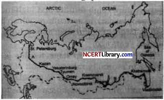
(1) Name the Railway line and name the country where it lies.
Answer:
Railway Line- Trans-Siberian Railway Line. It Lies in Asiatic Russia.
(2) Name the stations marked as ‘A’ and ‘B’.
Answer:
Station A is Moscow. Station B is Chita.
(3) State two reasons why it is the most important route in Asia?
Answer:
(a) It has helped in opening up its Asian region to west European markets.
(b) Chita is an important agro-centre, and Irkutsk, a fur center connecting them to Odessa in the South.
Question 20.
What is meant by the density of population? Explain with examples the physical and economic factors which affect population distribution.
OR
With the help of a neat and labeled diagram, explain the three stages of the Demographic Transition Theory. [3]
Answer:
The ratio between the numbers of people to the per unit area of land is called the density of population. Therefore it presents the relationship between human and land. It is measured in persons per sq. km. It helps in getting a better understanding of spatial distribution of population in relation to land. The physical factors which affect population distribution are water supply, climate, relief (shape of the land), vegetation, soils and availability of natural resources and energy plays a significant rule.
For example, the north India plains, deltas and coastal plains have a higher proportion of population than other regions of the country. The economic factors which affect population distribution are mineral, urbanisation and industrialization. Areas with mineral deposits attract industries. Mining and industrial activities generate employment. Katanga Zambia copper belt in Africa is one such good example.
Greater educational and medical facilities, better communication and transportation options, and better work prospects are all provided by cities. People are drawn to cities by attractive urban life and availability public amenities. Cities expand as a people’s of the movement from rural to urban areas.
OR
The three stages of the Demographic Transition Theory that can be easily understood with the help of following diagram:
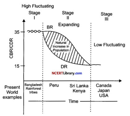
First Stage: Because humans reproduce more to make up for deaths brought by epidemics and erratic food supplies, the first stage features high fertility and high mortality, therefore population growth is sluggish. The majority of people work in agriculture, which benefits for big families. The average person has a short lifespan, is largely uneducated, and technologies. All of the nations in the world were at this level two hundred years ago.
Second Stage: In the beginning of the second stage, fertility is still high, but it gradually decreases with time. There is a decrease in mortality rate as a result of better sanitation and medical facilities. This gap contributes to the significant net increase in population.
Third Stage: Both fertility and mortality significantly decrease in the final period. Either the population remains constant or it increases slowly. The population actively limits the quantity of members in families also population engaged in urbanization, literate, and highly technological activities. This demonstrates how adaptable humans are and how they can change their fertility. Different nations are now in varying stages of demographic transformation.
Question 21.
Examine the features of cottage manufacturing or household industries. [3]
Answer:
The features of cottage manufacturing or household industries are:
(a) It is the smallest production unit.
(b) With the assistance of their families or supplemental labour, the artists create common items in their homes using simple tools and local raw materials.
(c) The final items may be used by the same household, sold in nearby (village) marketplaces, or traded for other goods.
(d) Capital and transportation do not wield much influence as this type of manufacturing has low commercial significance and most of the tools are devised locally.
(e) Foods, fabrics, mats, containers, tools, furniture, shoes, thongs and other items made from leather, ceramics, and bricks made from clay and stone are some common everyday items created in this sector of production.
(f) Jewellery made of gold, silver, and bronze is crafted by goldsmiths. Bamboo, a locally sourced wood from the forests, is used to create several artifacts and crafts.
Question 22.
How is ‘Naturalisation of Humans’ different from ‘Humanisation of Nature’?
OR
“The approaches to the study of human geography have been evolving over a period of time”. How have these schools of thought changed the approaches of study to human geography? [3]
| Naturalisation of Humans | Humanisation of Nature |
| (a) This relates to the early stages of human contact with nature, when people are still adapting to the laws of nature. | This refers to the relationship between natural forces and humans who begin to understand the force of nature. |
| (b) It suggests a very basic state of society and technological progress. | It denotes the advancement of effective technology as well as improved social and cultural ties. |
| (c) Humans who have become more like nature pay attention to it, fear its wrath, and revere it. | Humans transition from a position of dependence to a state of freedom. |
| (d) Direct reliance of humanity on the natural world. | The environment provides resources that are used to produce greater opportunities. |
| (e) Mother Nature becomes the physical environment for naturalised humans. | Humans use nature in such a way that it becomes more humane and bears the marks of human activity. |
OR
(a) The welfare or humanistic school of thinking in human geography focused primarily on the various facets of a person’s social well-being.
(b) These included of things like housing, healthcare, and education.
(c) Geographers have already introduced a paper to the post-graduate curriculum called “Geography of Social Well-Being.”
(d) The fundamental cause of poverty, hardship, and social injustice was explained by the radical school of thought using Marxian theory. Contemporary social problem were related to the development of capitalism.
(e) The behavioural school of thought placed a strong emphasis on lived experience as well as how different social groups based on race, religion, and other factors perceive space.
Question 23.
Elucidate any 3 characteristics of the most effective and advanced personal communication system in India. [3]
Answer:
(a) Internet is the most efficient and cutting-edge personal communication system available in India.
(b) It enables the user to gain entry to the knowledge-based world and information.
(c) The internet functions as a big central data storage facility with extensive information on a range of things.
(d) The internet-based network provides quick access to information at a relatively lower cost.
(e) It provides us with the fundamental tools for direct communication.
(f) More and more people are using it for e-commerce and conducting money transactions.
![]()
Section – C (25 Marks)
Question 24.
Describe the main characteristics of Intensive Subsistence Agriculture. In which parts of the world this type of agriculture is practiced? [5]
Answer:
This type of agriculture is largely found in densely populated regions of Monsoon Asia.
There are two types of intensive subsistence agriculture.
(i) Intensive subsistence agriculture dominated by wet paddy cultivation
(a) The rice crop is the dominant one in this type of agriculture.
(b) Small land holdings are a result of the high population density.
(c) Farmers work with the help of family labour resulting in extensive utilisation of the land.
(d) There is little use of automation in agriculture, and majority of work is done by hand.
(e) Manure from farmyards is used to retain soil fertility.
(f) The yield per unit area is high in this type of agriculture, but the labour productivity is low.
(ii) Intensive subsidence agriculture dominated by crops other than paddy
(a) In many areas of monsoon Asia, paddy cannot be grown due to differences in relief, climate, soil, and several other geographical characteristics.
(b) Northern China, Manchuria, North Korea, and North Japan cultivate wheat, soybean, barley, and sorghum.
(c) In India, wheat what is grown in western part of Indo-Gangetic plains and millets are grown in dry parts of western and southern India.
(d) Several features of this kind of agriculture are comparable to those that are characterised by wet climate areas except that irrigation is frequently employed in paddy. This type of agriculture is largely practised in densely populated regions of monsoon Asia.
Question 25.
Discuss the problems of Slums and Urban Waste Disposal in developing countries like India. [5]
Answer:
Slums, jhuggi-jhopari clusters, and shanty colonies are significant issues in urban areas of developing nations like India.
- These are home to persons who were compelled to move from rural areas to these urban centres in pursuit of work but are unable to afford decent housing due to high rent and high land expenses.
- They reside in deteriorated and unfriendly environmentally areas.
- Slums are residential area characterised by dilapidated housing, unsanitary conditions, poor ventilation, and lack of essential services like electricity, toilets and drinking water.
- There are significant health and socio-environmental problems associated with open defecation, uncontrolled drainage systems, and crowded, narrow street patterns.
- A majority of slum dwellers are employed in unorganised, low-wage, high-risk sectors of the urban economy.
- As a result, they are malnourished, prone to various illnesses, and unable to provide their children with quality education.
- Due to poverty, they are more prone to crime, vandalism, theft, escapism, apathy, and, eventually, social exclusion.
Question 26.
How have good governance and people-oriented policies with reference to the pillars of human development, increased the values of freedom and capabilities? [5]
OR
“The ways to measure human development are constantly being redefined”. Evaluate this statement keeping in mind the attainments and shortfalls in human development.
Answer:
Leading a long and healthy life, being able to gain knowledge and having sufficient means to be able to live a decent life are the most important aspects of human development. The idea of human development is supported by the concepts of equity, sustainability, productivity and empowerment.
(a) Equity refers to making equal access to opportunities available to everybody. People must have equal chances, regardless of their gender, ethnicity, income and caste. However, in practice, this is not always the same pattern for every community. For instance, it is intriguing to find out which group comprises the majority of school dropouts in any country.
The causes of such behaviour should then become clear as a result of this. In India, many women and people from economically and socially disadvantaged sections drop out of higher education. This demonstrates how lack of knowledge restricts these groups’ options.
(b) Sustainability means continuity in the availability of opportunities. These opportunities must be available to all generations in order to ensure sustainable human development. Every resource—environmental, financial, and human—must be used keeping the long term in mind. Future generations will have less opportunities if any of these resources is overused. An excellent illustration of this is the significance of sending girls to school.
If a community does not emphasize how important it is for its girl children to attend school, these young women will miss out on many opportunities when they grow up. Their professional options will be very limited, which will have a negative impact on other spheres of their lives. Therefore, every generation must ensure that its following generations have access to all options and opportunities.
(c) Productivity here means human labour productivity or productivity in terms of human work. By enhancing people’s talents, such productivity must be continuously improved. Ultimately, it is the people who are the real wealth of a nation. Therefore, making efforts to increase their knowledge and provide better health facilities to them ultimately leads to better work efficiency.
(d) Empowerment means to have the power to make choices. Such authority results from expanding choice and capacity. To empower the individuals, good governance and people-centered policies are necessary. It is especially important to empower socially and economically disadvantaged people.
OR
Newer approaches to capturing various aspects of human development are continually being developed. Research is being done on various aspects of human development. Researchers have discovered connections between political freedom or corruption in a specific area. There is also a discussion regarding a political freedom index and a listing of the most corrupt countries.
The human development index gauges progress in this sphere. It illustrates the advancements made in the primary spheres of human growth. However, it is not the most accurate indicator. This is because it does not say anything about the distribution of resources. The human development index and the human poverty index are interconnected. This index assesses the gap in human development. It is not an indicator of income.
To demonstrate the lack of human development in any sphere, several factors such as the likelihood of not living past the age of 40, the percentage of adults who are illiterate, the number of people without access to clean water, and the number of young children who are underweight are all taken into consideration to show the shortfall in human development in any region often the human poverty index is more revealing than the human development index. Together, these two indicators of human development paint a complete picture of the state of human development in a nation.
Question 27.
Justify the tremendous growth of the service sector in developed and developing countries than the manufacturing sector? Explain giving suitable examples. [5]
Answer:
Service Sector in developed and developing countries is growing faster than the manufacturing sector.
The reasons for this are:
(a) Highly advanced tools and technologies are available at present time. Due to the manufacturing industry’s ability to be operated and controlled by a small number of people, many individuals who were previously employed in the manufacturing sector are now looking for work in the service sector.
(b) A majority of manufacturing firms require a lot of labourers in non-production-related fields, such as administrative, management, advertising, sales, legal, and financial professionals, who earn more than those employed in direct production.
(c) The service sector is becoming more significant because it offers a better working environment and higher per capita income than the manufacturing sector, which attracts an increasing number of female job seekers.
(d) People look for better more healthcare, entertainment, hospitality, travel, and other services as their income rises. The service industry has thus dramatically expanded in all directions. The fact that these sectors employ so many people is a very positive development. For instance, as tourism rises, more jobs in the hotel sector become available.
(e) Growth in the service sector is a sign of rising GDP. Therefore, the government takes every effort to develop the service industry by providing many measures such as employees provident funds, gratuities, pensions, etc. Additionally, this also increases the population’s per capita income.
Question 28.
Analyse any five problems faced by Indian farmers in agriculture.
OR
On the basis of the main source of moisture for crops, analyse the types of farming in the Indian scenario. [5]
Answer:
Problems of Indian Agriculture: The agroecological conditions and historical experiences of India’s various regions impact the kind of issues that Indian agriculture faces. As a result, the majority of the nation’s agricultural issues are regional in nature. However, some issues are widespread and span from institutional obstacles to physical limitations.
Dependence on Erratic Monsoon: In India, only around 33% of the area used for agriculture is irrigated. The rest of the farmed land’s crop yield is purely dependent on rainfall. The supply of canal water for irrigation is also adversely affected by southwest monsoon’s poor performance. On the other hand, Rajasthan and other drought-prone regions receive too little and very erratic rainfall.
Even places with high annual rainfall are subject to significant variations. Due to this, they are susceptible to both floods and droughts. The low rainfall regions, occasionally are also prone to floods and drought. A 2006 instance of this phenomena occurred in the drylands of Maharashtra, Gujarat and Rajasthan. Floods and droughts continue to pose major threats to Indian agriculture.
Low productivity: Compared to other countries, the yield of the crops in the nation is poor. Per hectare output of most of the crops, including rice, wheat, cotton and oilseeds produced in India is lower than that in the United States, Russia, and Japan. This is because of the severe pressure on land resources, labour productivity in Indian agriculture is also low in comparison to international level. The yields are quite poor throughout the large rainfed regions of the nation, notably in the drylands where coarse grains, pulses and oilseeds are primarily grown.
Constraints of Financial Resources and Indebtedness: Modem agriculture requires a lot of pricey inputs. Due to their little or non-existent savings for agricultural investments, marginal and small farmers are no longer able to adopt this resource-intensive technique. A majority of these farmers have turned to borrowing money from banks and other financial organisations in order to sustain themselves by during these tough times.
Due to crop failures and low agricultural returns, they are compelled to fall into the debt trap. Lack of Commercialisation- Many farmers grow crops for their own consumption. These farmers do not have enough land resources to produce more than what they need. The majority of small and marginal farmers cultivate grains only for their own family’s consumption.
Vast Underemployment: Particularly in the unirrigated areas, India’s agriculture sector suffers from severe underemployment. In these areas seasonal unemployment lasts between 4 to 8 months. Even in the cropping, season, work is not available throughout as agriculture does not have the ability to work round the year.
Lack of Land Reforms: Indian peasantry had been exploited for a long time as there had been unequal distribution of land. Among the three revenue systems operational during the British period, i.e., Mahalwari, Ryotwari and Zamindari, the last one was most exploitative for the peasants. After independence, land reforms were accorded priority, but these reforms were not implemented effectively due to lack of strong political will.
Most of the state governments avoided taking politically tough decisions which went against the strong political lobbies of landlords. Lack of implementation of land reforms has resulted in a continuation of iniquitous distribution of cultivatable land, which is detrimental to agricultural development.
Landholding: There are a large number of marginal and small farmers in the country. The average size of land holding is shrinking under increasing population pressure. Furthermore, in India, the land holdings are mostly fragmented. There are some states where consolidation of holdings has not been carried out even once.
Even in the states where it has been carried out once, second consolidation is required as land holdings have fragmented again in the process of division of land among the owners of next generations. The small size of fragmented landholdings proves to be uneconomic.
OR
On the basis of the main source of moisture for crops, farming can be classified into irrigated and rainfed (barani).
- Irrigated farming has different characteristics depending on whether it is being done for protective or productive purposes.
- The objective of protective irrigation is to shield the crops from the negative impacts of soil moisture deficiency, which often means that irrigation acts as a supplement source of water over and above the rainfall. The goal of this type of irrigation is to moisten the soil over the largest possible area.
- In order to attain high crop output, productive irrigation supplies the soil with enough moisture during the growing season. In this type of irrigation, more water is used per unit area of cultivable land than in protective irrigation.
- According to how well the soil is moistened during the growing season, rainfed farming is further divided into dryland and wetland farming. In India, dryland farming is primarily limited to areas with annual precipitation of less than 75 cm. Ragi, bajra, moong, gram and guar (fodder crops) are hardy and drought-resistant crops that are grown in these areas together with various techniques for conserving soil moisture and rainwater harvesting.
- During the rainy season, wetland farming receives more precipitation than the plants’ soil moisture requirement. Flooding and soil erosion are potential risks in these areas. Formers of these regions practise aquaculture in the freshwater bodies and grow a variety of crops that require a lot of water, such as rice, jute and sugarcane.
![]()
Section – D (10 Marks)
Question 29.
On the given political map of the world, the following seven features are shown. Identify any five of these features and write their correct names on the lines marked near each feature. [5]
A. A Shipping Canal
B. An International Airport
C. An International Seaport
D. An area of Extensive Commercial Grain farming
E. A Nomadic Herding area
F. Largest Country of South America
G. A Major Seaport
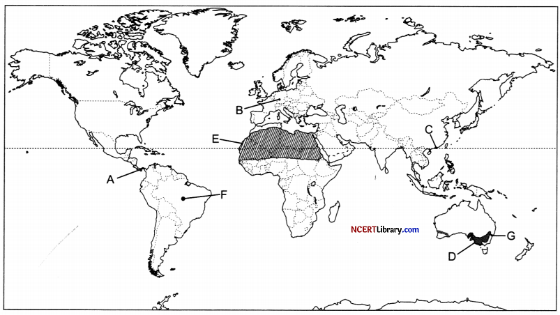
Answer:
A. A Shipping Canal – Panama Canal
B. An International Airport – Frankfurt Airport
C. An International Seaport – Hong Kong Port
D. An area of Extensive Commercial Grain farming – Downs
E. A Nomadic Herding area – Sub Sahara or Sahara Desert
F. Largest Country of South America – Brazil
G. A Major Seaport – Sydney Port
Question 30.
On the given political map of India, locate and label any five of the following with appropriate symbols: [5]
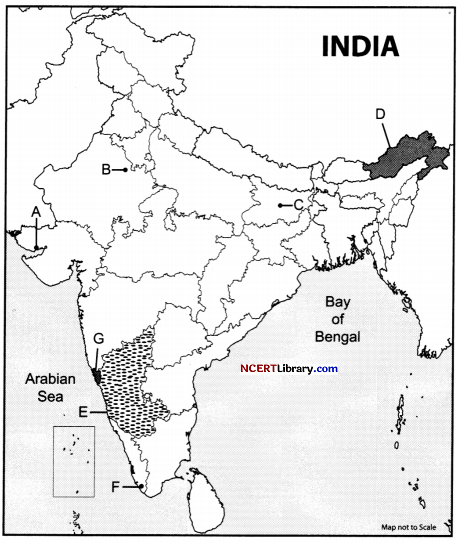
A. Northern-most Seaport on Western coast of India
B. A copper mine of Rajasthan
C. A market-based oil refinery located in Bihar
D. State with the lowest population density
E. Largest coffee-producing state
F. An international airport of Kerala
G. A state with highest level of urbanization
Answer:
A. Northernmost Seaport on Western coast of India – Kandla
B. A copper mine of Rajasthan – Khetri
C. A market-based oil refinery located in Bihar – Barauni
D. State with lowest population density – Arunanchal Pradesh
E. Largest coffee-producing state – Karnataka
F. An international airport of Kerala – Thiruvananthapuram
G. A state with highest level of urbanization- Goa